Hills of Britain and Ireland
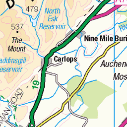
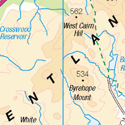
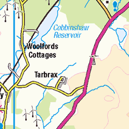
OS Map of Wether Law
Height: 479m / 1572ft • Prominence: 209m / 686ft • Summit : trig point • Trip reports (hill-bagging)


11198 - Peat Hill
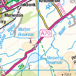
NT206486, LR73. HISTORY The pillar was completed on 14th February 1966, cost unknown. Computed as tertiary triangulation station NT48/T183 within the Edinburgh secondary block, and levelled to second class precision during 1966. This pillar station was last maintained by the Ordnance Survey in July 1981. This Peeblesshire triangulation pillar is considerably younger than any of the neighbouring trig pillars. It is a late addition to the network, hence its high and numerically outlying FB number. It was built as a base station for the Royal Observatory. The cavity at the back (NE face) once housed a plaque which was fluorescent so it could be used at night [OS]. This plaque was gone by 1986. SITE VISIT Circuitous approach from the northeast. Visited in conjunction with S3134, Wether Law. Parked by the junction of tracks at NT222498. Followed the mapped track network to NT204484 then up a steep break to the summit. Wooded hill with a clearing at the top. The pillar is in good condition. The spider retains its original OS centre cap with raised small letters. The flush bracket faces WSW, compass measurement 253°. Vented through the front (FB face) and back sight holes. The innards are filled with debris. No views due to the surrounding conifers. Continued to Wether Law via the steep break at NT202485. Photographed: 17th February 2013, GRP. ═════════════════════════ Interactive index: www.google.com/maps/d/viewer?mid=1arx2Qmo5mVeVUJA2lzVG_uzbYPW59ffh&ll=55.724669,-3.265681&z=12" rel="noreferrer nofollow Google My Maps Map: www.flickr.com/photos/13460108@N06/43595282831/in/album-72157692190778971 Trig Pillars on OS Landranger 73 ═════════════════════════ Neighbouring Triangulation Pillars www.flickr.com/photos/13460108@N06/7944623150/in/set-72157631347423092/ S3134 - Wether Law : 0.72 miles to the west. www.flickr.com/photos/13460108@N06/7944623004/in/set-72157631347423092/ S3135 - Grange Hill : 1.76 miles to the north. www.flickr.com/photos/13460108@N06/7944622688/in/set-72157631347423092/ S3137 - Broomlee Hill : 2.94 miles to the northwest. www.flickr.com/photos/13460108@N06/7905059740/in/set-72157631347423092/ S3079 - West Loch : 3.44 miles to the northeast. www.flickr.com/photos/13460108@N06/8117246417/in/set-72157631838876970/ 10235 - White Meldon : 3.70 miles to the south. www.flickr.com/photos/13460108@N06/7905058828/in/set-72157631347423092/ S3089 - Dundreich : 4.28 miles to the east. www.flickr.com/photos/13460108@N06/7944622328/in/album-72157631347423092/ S3139 - Auchencorth Moss : 4.4 miles to the north. www.flickr.com/photos/13460108@N06/7944622866/in/album-72157631347423092/ S3136 - Blyth Muir : 4.6 miles to the west. www.flickr.com/photos/13460108@N06/7905059636/in/album-72157631347423092/ S3080 - Kingside Edge : 4.9 miles to the northeast. ═════════════════════════
17-Feb-13 • Graeme5015 • flickr
observatory peathill 11198 westlinton cloich cloichhills 8126040883

S3134 - Wether Law
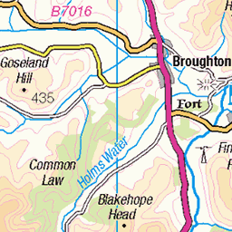
NT194483, LR72. HISTORY Pillar completed 28th September 1943 costing £15.3s.6d. Computed as tertiary station NT48/2 within the Edinburgh secondary block during 1943. The station number implies that this station must have been initially intended as a secondary station. This station was also used for the reconnaissance of secondary block NT33 (Peebles), and was levelled to second class precision during 1959. This pillar station was last maintained by the OS in November 1987. SITE VISIT Circuitous approach from NE, visited with 11198, Peat Hill. Parked by junction of tracks at NT222498. Followed mapped track network to steep break at NT202485 (bagging Peat Hill first), down to open grazing hill and straight line to summit. Open grazing land. Pillar in fair condition. Spider has replacement OS centre cap with raised weathered large narrow letters. Flush bracket faces NNW, ~342. Sight holes all plugged. 360° panoramic open outlook from top. Returned through quicker woodland break via NT202487. Photographed: 17th February 2013, GRP. ═════════════════════════ Interactive index: www.google.com/maps/d/viewer?mid=1arx2Qmo5mVeVUJA2lzVG_uzbYPW59ffh&ll=55.722083,-3.283667&z=12" rel="noreferrer nofollow Google My Maps Map: www.flickr.com/photos/13460108@N06/43496070241/in/album-72157692190778971/ Trig Pillars on OS Landranger 72 ═════════════════════════ Neighbouring Triangulation Pillars www.flickr.com/photos/13460108@N06/8126040883/in/set-72157631859989543 11198 - Peat Hill : 0.72 miles to the east. www.flickr.com/photos/13460108@N06/7944623004/in/set-72157631347423092/ S3135 - Grange Hill : 1.96 miles to the north. www.flickr.com/photos/13460108@N06/7944622688/in/set-72157631347423092/ S3137 - Broomlee Hill : 2.45 miles to the northwest. www.flickr.com/photos/13460108@N06/8117246417/in/set-72157631838876970/ 10235 - White Meldon : 3.76 miles to the southeast. www.flickr.com/photos/13460108@N06/7944622866/in/set-72157631347423092 S3136 - Blyth Muir : 3.85 miles to the west. www.flickr.com/photos/13460108@N06/7905059740/in/set-72157631347423092/ S3079 - West Loch : 4.12 miles to the northeast. www.flickr.com/photos/13460108@N06/7944622328/in/set-72157631347423092/ S3139 - Auchencorth Moss : 4.46 miles to the north. www.flickr.com/photos/13460108@N06/7942010002/in/album-72157631432527440/ S2655 - Mendick Hill : 4.74 miles to the west. www.flickr.com/photos/13460108@N06/7905058828/in/album-72157631347423092/ S3089 - Dundreich : 4.99 miles to the east. ═════════════════════════ Distant Intervisible Pillars www.flickr.com/photos/13460108@N06/7905064354/in/set-72157631347423092/ S3092 - Allermuir Hill : 11.241 miles, grid bearing 10.311° www.flickr.com/photos/13460108@N06/7905063844/in/album-72157631347423092/ S3012 - Arthurs Seat : 16.070 miles, grid bearing 18.178° www.flickr.com/photos/13460108@N06/7905058828/in/album-72157631347423092/ S3089 - Dundreich : 4.993 miles, grid bearing 84.868° www.flickr.com/photos/13460108@N06/8109884701/in/album-72157631821839859/ S8052 - Tinto : 17.367 miles, grid bearing 239.928° www.flickr.com/photos/13460108@N06/7942010002/in/set-72157631432527440/ S2655 - Mendick Hill : 4.737 miles, grid bearing 286.439° www.flickr.com/photos/13460108@N06/7905059316/in/set-72157631347423092/ S3084 - West Cairn Hill : 8.262 miles, grid bearing 318.929° www.flickr.com/photos/13460108@N06/7942010160/in/set-72157631432527440 S2654 - Mount Maw : 5.546 miles, grid bearing 323.309° www.flickr.com/photos/13460108@N06/7905745250/in/set-72157631348956488 S1573 - Scald Law : 7.899 miles, grid bearing 358.656° ═════════════════════════
17-Feb-13 • Graeme5015 • flickr
wetherlaw s3134 westlinton romannobridge 7944623150
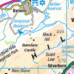
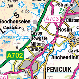
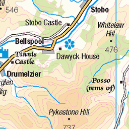
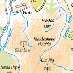
OS Map
This is OS mapping. In some areas, OpenStreetMap shows more footpaths
Spatial NI has online OSNI mapping. Click "Basemap Gallery" (4 squares icon at the top).
Now would be a good time for a cup of tea.
GPX Editor
Record map clicks
Reload map
Photos
Please tag your photos and upload them to the British and Irish Mountains group on Flickr
The other photos have been geo-tagged as on or around the summit. For less busy mountains, it can be a little hit and miss.
11198 - Peat Hill
NT206486, LR73. HISTORY The pillar was completed on 14th February 1966, cost unknown. Computed as tertiary triangulation station NT48/T183 within the Edinburgh secondary block, and levelled to second class precision during 1966. This pillar station was last maintained by the Ordnance Survey in July 1981. This Peeblesshire triangulation pillar is considerably younger than any of the neighbouring trig pillars. It is a late addition to the network, hence its high and numerically outlying FB number. It was built as a base station for the Royal Observatory. The cavity at the back (NE face) once housed a plaque which was fluorescent so it could be used at night [OS]. This plaque was gone by 1986. SITE VISIT Circuitous approach from the northeast. Visited in conjunction with S3134, Wether Law. Parked by the junction of tracks at NT222498. Followed the mapped track network to NT204484 then up a steep break to the summit. Wooded hill with a clearing at the top. The pillar is in good condition. The spider retains its original OS centre cap with raised small letters. The flush bracket faces WSW, compass measurement 253°. Vented through the front (FB face) and back sight holes. The innards are filled with debris. No views due to the surrounding conifers. Continued to Wether Law via the steep break at NT202485. Photographed: 17th February 2013, GRP. ═════════════════════════ Interactive index: www.google.com/maps/d/viewer?mid=1arx2Qmo5mVeVUJA2lzVG_uzbYPW59ffh&ll=55.724669,-3.265681&z=12" rel="noreferrer nofollow Google My Maps Map: www.flickr.com/photos/13460108@N06/43595282831/in/album-72157692190778971 Trig Pillars on OS Landranger 73 ═════════════════════════ Neighbouring Triangulation Pillars www.flickr.com/photos/13460108@N06/7944623150/in/set-72157631347423092/ S3134 - Wether Law : 0.72 miles to the west. www.flickr.com/photos/13460108@N06/7944623004/in/set-72157631347423092/ S3135 - Grange Hill : 1.76 miles to the north. www.flickr.com/photos/13460108@N06/7944622688/in/set-72157631347423092/ S3137 - Broomlee Hill : 2.94 miles to the northwest. www.flickr.com/photos/13460108@N06/7905059740/in/set-72157631347423092/ S3079 - West Loch : 3.44 miles to the northeast. www.flickr.com/photos/13460108@N06/8117246417/in/set-72157631838876970/ 10235 - White Meldon : 3.70 miles to the south. www.flickr.com/photos/13460108@N06/7905058828/in/set-72157631347423092/ S3089 - Dundreich : 4.28 miles to the east. www.flickr.com/photos/13460108@N06/7944622328/in/album-72157631347423092/ S3139 - Auchencorth Moss : 4.4 miles to the north. www.flickr.com/photos/13460108@N06/7944622866/in/album-72157631347423092/ S3136 - Blyth Muir : 4.6 miles to the west. www.flickr.com/photos/13460108@N06/7905059636/in/album-72157631347423092/ S3080 - Kingside Edge : 4.9 miles to the northeast. ═════════════════════════
17-Feb-13 • Graeme5015 • flickr
observatory peathill 11198 westlinton cloich cloichhills 8126040883
S3134 - Wether Law
NT194483, LR72. HISTORY Pillar completed 28th September 1943 costing £15.3s.6d. Computed as tertiary station NT48/2 within the Edinburgh secondary block during 1943. The station number implies that this station must have been initially intended as a secondary station. This station was also used for the reconnaissance of secondary block NT33 (Peebles), and was levelled to second class precision during 1959. This pillar station was last maintained by the OS in November 1987. SITE VISIT Circuitous approach from NE, visited with 11198, Peat Hill. Parked by junction of tracks at NT222498. Followed mapped track network to steep break at NT202485 (bagging Peat Hill first), down to open grazing hill and straight line to summit. Open grazing land. Pillar in fair condition. Spider has replacement OS centre cap with raised weathered large narrow letters. Flush bracket faces NNW, ~342. Sight holes all plugged. 360° panoramic open outlook from top. Returned through quicker woodland break via NT202487. Photographed: 17th February 2013, GRP. ═════════════════════════ Interactive index: www.google.com/maps/d/viewer?mid=1arx2Qmo5mVeVUJA2lzVG_uzbYPW59ffh&ll=55.722083,-3.283667&z=12" rel="noreferrer nofollow Google My Maps Map: www.flickr.com/photos/13460108@N06/43496070241/in/album-72157692190778971/ Trig Pillars on OS Landranger 72 ═════════════════════════ Neighbouring Triangulation Pillars www.flickr.com/photos/13460108@N06/8126040883/in/set-72157631859989543 11198 - Peat Hill : 0.72 miles to the east. www.flickr.com/photos/13460108@N06/7944623004/in/set-72157631347423092/ S3135 - Grange Hill : 1.96 miles to the north. www.flickr.com/photos/13460108@N06/7944622688/in/set-72157631347423092/ S3137 - Broomlee Hill : 2.45 miles to the northwest. www.flickr.com/photos/13460108@N06/8117246417/in/set-72157631838876970/ 10235 - White Meldon : 3.76 miles to the southeast. www.flickr.com/photos/13460108@N06/7944622866/in/set-72157631347423092 S3136 - Blyth Muir : 3.85 miles to the west. www.flickr.com/photos/13460108@N06/7905059740/in/set-72157631347423092/ S3079 - West Loch : 4.12 miles to the northeast. www.flickr.com/photos/13460108@N06/7944622328/in/set-72157631347423092/ S3139 - Auchencorth Moss : 4.46 miles to the north. www.flickr.com/photos/13460108@N06/7942010002/in/album-72157631432527440/ S2655 - Mendick Hill : 4.74 miles to the west. www.flickr.com/photos/13460108@N06/7905058828/in/album-72157631347423092/ S3089 - Dundreich : 4.99 miles to the east. ═════════════════════════ Distant Intervisible Pillars www.flickr.com/photos/13460108@N06/7905064354/in/set-72157631347423092/ S3092 - Allermuir Hill : 11.241 miles, grid bearing 10.311° www.flickr.com/photos/13460108@N06/7905063844/in/album-72157631347423092/ S3012 - Arthurs Seat : 16.070 miles, grid bearing 18.178° www.flickr.com/photos/13460108@N06/7905058828/in/album-72157631347423092/ S3089 - Dundreich : 4.993 miles, grid bearing 84.868° www.flickr.com/photos/13460108@N06/8109884701/in/album-72157631821839859/ S8052 - Tinto : 17.367 miles, grid bearing 239.928° www.flickr.com/photos/13460108@N06/7942010002/in/set-72157631432527440/ S2655 - Mendick Hill : 4.737 miles, grid bearing 286.439° www.flickr.com/photos/13460108@N06/7905059316/in/set-72157631347423092/ S3084 - West Cairn Hill : 8.262 miles, grid bearing 318.929° www.flickr.com/photos/13460108@N06/7942010160/in/set-72157631432527440 S2654 - Mount Maw : 5.546 miles, grid bearing 323.309° www.flickr.com/photos/13460108@N06/7905745250/in/set-72157631348956488 S1573 - Scald Law : 7.899 miles, grid bearing 358.656° ═════════════════════════
17-Feb-13 • Graeme5015 • flickr
wetherlaw s3134 westlinton romannobridge 7944623150
Videos
We get lucky with the weather again as we head toward Edinburgh for a walk in the Pentlands, walking a route including West Kip.
Notes
- Data: Database of British and Irish Hills v18.2
- Maps: We use OS mapping for England, Scotland, Wales, and the Isle of Man. Sadly, Channel Islands, Northern (OSNI) and Southern Ireland (OSI) mapping isn't available online, so we use Openstreetmap.