Hills of Britain and Ireland
OS Map of Cairn Table
Height: 593m / 1946ft • Prominence: 323m / 1060ft • Summit : trig point • Trip reports (hill-bagging)


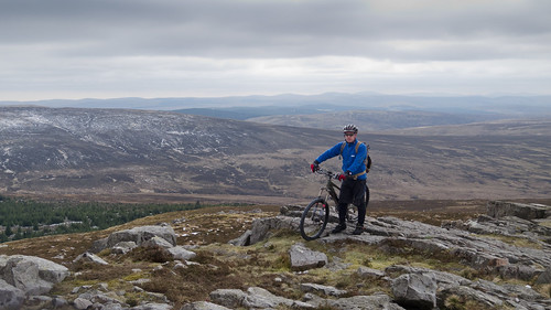
Cairn Table
Another trip to the summit by bike, the ride back down makes the climb worth it. This view is looking south from the trig point. Location >> | www.robogeo.com/Flickr2Map/?type=map" target="_blank" rel="nofollow Map | www.robogeo.com/Flickr2Map/?type=map&view=satellite" target="_blank" rel="nofollow Satellite | www.robogeo.com/Flickr2Map/?type=map&view=hybrid" target="_blank" rel="nofollow Hybrid | www.robogeo.com/Flickr2Map/?type=map&view=terrain" target="_blank" rel="nofollow Terrain | www.robogeo.com/Flickr2Map/" rel="nofollow Google Earth |
05-Apr-12 • John C Ayr • flickr
bike geotagged view walk hill east mtb summit cairn ayrshire muirkirk cairntable geo:lat=5549522382654403 geo:lon=4020874548599295 6906020306
OS Map
This is OS mapping. In some areas, OpenStreetMap shows more footpaths
Spatial NI has online OSNI mapping. Click "Basemap Gallery" (4 squares icon at the top).
Now would be a good time for a cup of tea.
GPX Editor
Record map clicks
Reload map
Photos
Please tag your photos and upload them to the British and Irish Mountains group on Flickr
The other photos have been geo-tagged as on or around the summit. For less busy mountains, it can be a little hit and miss.
Cairn Table
Another trip to the summit by bike, the ride back down makes the climb worth it. This view is looking south from the trig point. Location >> | www.robogeo.com/Flickr2Map/?type=map" target="_blank" rel="nofollow Map | www.robogeo.com/Flickr2Map/?type=map&view=satellite" target="_blank" rel="nofollow Satellite | www.robogeo.com/Flickr2Map/?type=map&view=hybrid" target="_blank" rel="nofollow Hybrid | www.robogeo.com/Flickr2Map/?type=map&view=terrain" target="_blank" rel="nofollow Terrain | www.robogeo.com/Flickr2Map/" rel="nofollow Google Earth |
05-Apr-12 • John C Ayr • flickr
bike geotagged view walk hill east mtb summit cairn ayrshire muirkirk cairntable geo:lat=5549522382654403 geo:lon=4020874548599295 6906020306

Cairn Table
The giant cairn atop Cairn Table near Muirkirk.This is more a climb than a walk and from the top of the hill on a clear day, the Isle of Arran, Ben Lomond and the Galloway Hills can be seen.
06-Nov-10 • JACK BYERS. • flickr
scotland hill muirkirk cairntable jackbyers 5904220850

S1562 - Cairn Table
NS724242, LR71. HISTORY Pillar completed in 1936, exact date and cost not on record. Computed as primary station PP311 within Figure 3 of the OSGB36 network during 1937. Levelled to second class precision in 1950. The last pre-GPS maintenance by the OS was in June 1978. This marker continues to be maintained by the OS as a GPS passive station. SITE VISIT Approached via the mapped track from Kaims. Pillar in good order and painted white, GPS plate affixed. Spider has plastic plug. FB faces WSW, compass measurement 256°. LHS sighting hole plugged, others open. Long views in all directions including Tinto. Difficult to decide whether this pillar is in East Ayrshire or South Lanarkshire, but the former seems more likely. Photographed: 3rd March 2007, GRP. ═════════════════════════ Interactive index www.google.com/maps/d/viewer?mid=1arx2Qmo5mVeVUJA2lzVG_uzbYPW59ffh&ll=55.495123,-4.020881&z=12" rel="noreferrer nofollow Google My Maps Landranger: www.flickr.com/photos/13460108@N06/41647376710/in/album-72157692190778971/ Trig Pillars on OS Landranger 71 ═════════════════════════ Neighbouring Triangulation Pillars www.flickr.com/photos/13460108@N06/8098002596/in/album-72157631793900484/ S6107 - Parishholm Hill : 3.45 miles to the northeast. www.flickr.com/photos/13460108@N06/8103203582/in/album-72157631778814317/ S5414 - Cairnkinny : 4.13 miles to the southeast. www.flickr.com/photos/13460108@N06/8103188385/in/album-72157631778814317/ S5475 - Middlefield Law : 4.85 miles to the northwest. www.flickr.com/photos/13460108@N06/8097991774/in/album-72157631793900484/ S6091 - Kirkland Hill : 4.96 miles to the south. www.flickr.com/photos/13460108@N06/8098002520/in/album-72157631793900484/ S6108 - Common Hill : 5.88 miles to the northeast. www.flickr.com/photos/13460108@N06/8094748862/in/album-72157631778814317/ S5982 - Shiel Hill : 6.09 miles to the southeast. ═════════════════════════
03-Mar-07 • Graeme5015 • flickr
cairntable s1562 glenbuck 7905746082
Videos
Cairn table loop at Muirkirk, easy enough wee hike but boggy in places.
Cairn Table With Donna 18th April 2023 Brilliant day & hike. We have been planning this hike for a while and finally we were both ...
Our walk up Cairntable from the Sanquhar Bridge direction. Some mixed weather as it was cold and frosty on arrival. 90 mins later ...
Notes
- Data: Database of British and Irish Hills v18.2
- Maps: We use OS mapping for England, Scotland, Wales, and the Isle of Man. Sadly, Channel Islands, Northern (OSNI) and Southern Ireland (OSI) mapping isn't available online, so we use Openstreetmap.