Hills of Britain and Ireland
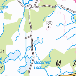
OS Map of Meikle Mulltaggart


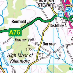
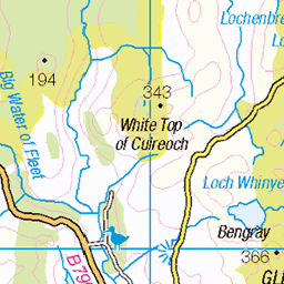
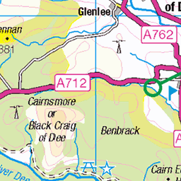
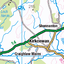
S1561 - Cairnsmore Of Fleet
NX501670, LR83. HISTORY Pillar completed 5th June 1936 costing £24.0s.7d. Computed as primary triangulation station PP343 within Figure 3 of the OSGB36 Retriangulation of Great Britain primary network during 1937. Levelled to second class precision in 1958. Last maintained by the OS in June 1988. SITE VISIT Overall approach from southwest. Free public car park at NX462634. Followed mapped footpath via Cairnsmore Farm which leads all the way to the summit. Pillar could almost be classified as `damaged`. Large chip off one top apex, but the damage around the bottom is looking structural. Spider centre open, centre hole filled with stones. Flush bracket faces 121°, east. Vented through sight hole on FB face. Cloud down, no views on day of visit. My last Scottish S15** series pillar. Photographed: 8th August 2009, GRP. ═════════════════════════ Interactive index: www.google.com/maps/d/viewer?mid=1arx2Qmo5mVeVUJA2lzVG_uzbYPW59ffh&ll=54.975695,-4.342705&z=12" rel="noreferrer nofollow Google My Maps Map: www.flickr.com/photos/13460108@N06/39995539702 Trig Pillars on OS Landranger 83 ═════════════════════════ Neighbouring Triangulation Pillars www.flickr.com/photos/13460108@N06/8132124371/in/album-72157631874189130/ un74 - Round Fell : 3.79 miles to the northeast. www.flickr.com/photos/13460108@N06/8109904687/in/album-72157631821839859/ S8426 - Dunharberry : 4.53 miles to the east. www.flickr.com/photos/13460108@N06/8109905685/in/album-72157631821839859/ S8372 - Meikle Bennan : 4.60 miles to the southeast. www.flickr.com/photos/13460108@N06/8109895641/in/album-72157631821839859/ S8191 - Cree : 4.87 miles to the southwest. www.flickr.com/photos/13460108@N06/8136841094/in/album-72157631874189130/ un66 - Millfore : 5.41 miles to the north. www.flickr.com/photos/13460108@N06/8132120143/in/album-72157631874189130/ un49 - Garlick Hill : 5.66 miles to the northwest. www.flickr.com/photos/13460108@N06/8109895141/in/set-72157631821839859/ S8192 - Doon Hill : 6.16 miles to the west. www.flickr.com/photos/13460108@N06/8132121767/in/album-72157631874189130/ un20 - Cairnharrow : 7.11 miles to the south. ═════════════════════════
08-Aug-09 • Graeme5015 • flickr
cairnsmoreoffleet s1561 talnotry 7905746192
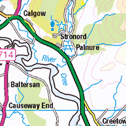
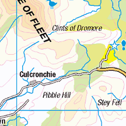
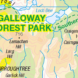
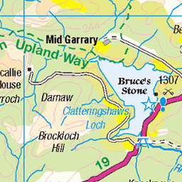
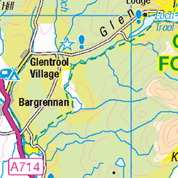
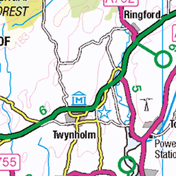
OS Map
This is OS mapping. In some areas, OpenStreetMap shows more footpaths
Spatial NI has online OSNI mapping. Click "Basemap Gallery" (4 squares icon at the top).
Now would be a good time for a cup of tea.
GPX Editor
Record map clicks
Reload map
Photos
Please tag your photos and upload them to the British and Irish Mountains group on Flickr
The other photos have been geo-tagged as on or around the summit. For less busy mountains, it can be a little hit and miss.
S1561 - Cairnsmore Of Fleet
NX501670, LR83. HISTORY Pillar completed 5th June 1936 costing £24.0s.7d. Computed as primary triangulation station PP343 within Figure 3 of the OSGB36 Retriangulation of Great Britain primary network during 1937. Levelled to second class precision in 1958. Last maintained by the OS in June 1988. SITE VISIT Overall approach from southwest. Free public car park at NX462634. Followed mapped footpath via Cairnsmore Farm which leads all the way to the summit. Pillar could almost be classified as `damaged`. Large chip off one top apex, but the damage around the bottom is looking structural. Spider centre open, centre hole filled with stones. Flush bracket faces 121°, east. Vented through sight hole on FB face. Cloud down, no views on day of visit. My last Scottish S15** series pillar. Photographed: 8th August 2009, GRP. ═════════════════════════ Interactive index: www.google.com/maps/d/viewer?mid=1arx2Qmo5mVeVUJA2lzVG_uzbYPW59ffh&ll=54.975695,-4.342705&z=12" rel="noreferrer nofollow Google My Maps Map: www.flickr.com/photos/13460108@N06/39995539702 Trig Pillars on OS Landranger 83 ═════════════════════════ Neighbouring Triangulation Pillars www.flickr.com/photos/13460108@N06/8132124371/in/album-72157631874189130/ un74 - Round Fell : 3.79 miles to the northeast. www.flickr.com/photos/13460108@N06/8109904687/in/album-72157631821839859/ S8426 - Dunharberry : 4.53 miles to the east. www.flickr.com/photos/13460108@N06/8109905685/in/album-72157631821839859/ S8372 - Meikle Bennan : 4.60 miles to the southeast. www.flickr.com/photos/13460108@N06/8109895641/in/album-72157631821839859/ S8191 - Cree : 4.87 miles to the southwest. www.flickr.com/photos/13460108@N06/8136841094/in/album-72157631874189130/ un66 - Millfore : 5.41 miles to the north. www.flickr.com/photos/13460108@N06/8132120143/in/album-72157631874189130/ un49 - Garlick Hill : 5.66 miles to the northwest. www.flickr.com/photos/13460108@N06/8109895141/in/set-72157631821839859/ S8192 - Doon Hill : 6.16 miles to the west. www.flickr.com/photos/13460108@N06/8132121767/in/album-72157631874189130/ un20 - Cairnharrow : 7.11 miles to the south. ═════════════════════════
08-Aug-09 • Graeme5015 • flickr
cairnsmoreoffleet s1561 talnotry 7905746192
Videos
None found
Notes
- Data: Database of British and Irish Hills v18.2
- Maps: We use OS mapping for England, Scotland, Wales, and the Isle of Man. Sadly, Channel Islands, Northern (OSNI) and Southern Ireland (OSI) mapping isn't available online, so we use Openstreetmap.