Hills of Britain and Ireland
OS Map of Huiseabhal Mor (Husival Mor)

SW from Orieabhal
01-Jun-19 • Geoff Buck • flickr
scotland hebrides lewis harris wildernessscotland highlands island orieabhal huiseabhal huisinis 47984720701

Fladaigh (island) and Traigh Mheilein (beach)
17-May-19 • Geoff Buck • flickr
scotland hebrides lewis harris wildernessscotland highlands island 47984695198

![1596 Huiseabhal Mor [Husival Mor] a](https://live.staticflickr.com/3928/15510293581_08c66711d5.jpg)
1596 Huiseabhal Mor [Husival Mor] a
Name:Huiseabhal Mor [Husival Mor] Hill number:1596 Height:489m / 1604ft Section:24B: Harris and Nearby Islands County/UA:Na h-Eileanan Siar [Western Isles] (UA) Island:Lewis and Harris Class:Marilyn, HuMP, Tump (400-499m) Grid ref:NB 02264 11609 Summit feature:cairn Drop:272m Col:217m NB039111
13-Sep-14 • Dugswell2 • flickr
marilyn isleofharris p272 huiseabhalmorhusivalmor 15510293581
![1596 Huiseabhal Mor [Husival Mor]](https://live.staticflickr.com/2949/15490273256_1aa0df7995.jpg)
1596 Huiseabhal Mor [Husival Mor]
Early morning ascent after parking near road junction at NB 01848 09641. Lots of rocks to walk up on a drier than normal hill. Super viewpoint as the good weather continues. Name:Huiseabhal Mor [Husival Mor] Hill number:1596 Height:489m / 1604ft Section:24B: Harris and Nearby Islands County/UA:Na h-Eileanan Siar [Western Isles] (UA) Island:Lewis and Harris Class:Marilyn, HuMP, Tump (400-499m) Grid ref:NB 02264 11609 Summit feature:cairn Drop:272m Col:217m NB039111
13-Sep-14 • Dugswell2 • flickr
marilyn isleofharris p272 huiseabhalmorhusivalmor 15490273256
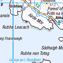
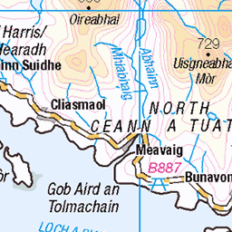
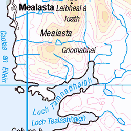
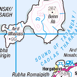
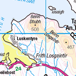
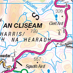
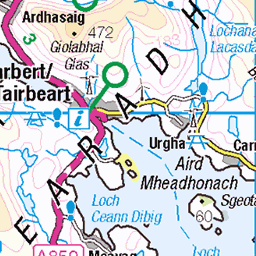
OS Map
This is OS mapping. In some areas, OpenStreetMap shows more footpaths
Spatial NI has online OSNI mapping. Click "Basemap Gallery" (4 squares icon at the top).
Now would be a good time for a cup of tea.


GPX Editor
Record map clicks
Reload map
Photos
Please tag your photos and upload them to the British and Irish Mountains group on Flickr
The other photos have been geo-tagged as on or around the summit. For less busy mountains, it can be a little hit and miss.
SW from Orieabhal
01-Jun-19 • Geoff Buck • flickr
scotland hebrides lewis harris wildernessscotland highlands island orieabhal huiseabhal huisinis 47984720701
Fladaigh (island) and Traigh Mheilein (beach)
17-May-19 • Geoff Buck • flickr
scotland hebrides lewis harris wildernessscotland highlands island 47984695198
1596 Huiseabhal Mor [Husival Mor] a
Name:Huiseabhal Mor [Husival Mor] Hill number:1596 Height:489m / 1604ft Section:24B: Harris and Nearby Islands County/UA:Na h-Eileanan Siar [Western Isles] (UA) Island:Lewis and Harris Class:Marilyn, HuMP, Tump (400-499m) Grid ref:NB 02264 11609 Summit feature:cairn Drop:272m Col:217m NB039111
13-Sep-14 • Dugswell2 • flickr
marilyn isleofharris p272 huiseabhalmorhusivalmor 15510293581
1596 Huiseabhal Mor [Husival Mor]
Early morning ascent after parking near road junction at NB 01848 09641. Lots of rocks to walk up on a drier than normal hill. Super viewpoint as the good weather continues. Name:Huiseabhal Mor [Husival Mor] Hill number:1596 Height:489m / 1604ft Section:24B: Harris and Nearby Islands County/UA:Na h-Eileanan Siar [Western Isles] (UA) Island:Lewis and Harris Class:Marilyn, HuMP, Tump (400-499m) Grid ref:NB 02264 11609 Summit feature:cairn Drop:272m Col:217m NB039111
13-Sep-14 • Dugswell2 • flickr
marilyn isleofharris p272 huiseabhalmorhusivalmor 15490273256
Videos
None found
Notes
- Data: Database of British and Irish Hills v18.2
- Maps: We use OS mapping for England, Scotland, Wales, and the Isle of Man. Sadly, Channel Islands, Northern (OSNI) and Southern Ireland (OSI) mapping isn't available online, so we use Openstreetmap.