Hills of Britain and Ireland
OS Map of Fitty Hill


IMG_2810
Through the door - Westray abandoned village
18-Jul-24 • andrewgiles23 • flickr
53886690130


1557 Fitty Hill a
29-May-14 • Dugswell2 • flickr
marilyn orkney trigpoint westray p169 fittyhill 14488898361

1557 Fitty Hill
Used the footpath via Lengemire which is now a ruin with Jim Bloomer and Tricky Speirs. Name:Fitty Hill Hill number:1557 Height:169m / 554ft Area:23: Orkney Islands Class:Ma,1 Grid ref: HY 42976 44856 Summit feature:trig point Drop:169m Col:Sea
29-May-14 • Dugswell2 • flickr
marilyn orkney trigpoint westray p169 fittyhill 14305664239

Westray Project 36 (HLS Almelo)
Heading up the hill side to the wind turbine site on Westray Island. Escorts & permits by Teahan Convoi Service.
05-Sep-12 • abloadescort • flickr
wideload oversizeload enercon heavyhaulage teahan abnormalload orkneyisles schwerlast convoiexceptionnel hlsalmelo stgoescorts alphatrans westrayisland 7982059531
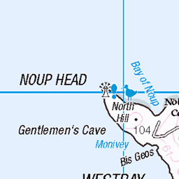
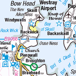
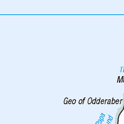
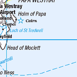
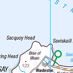
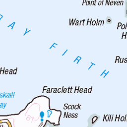
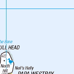
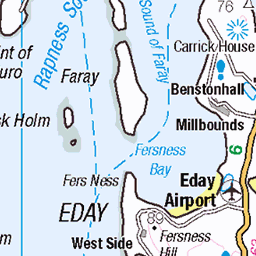
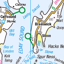
OS Map
This is OS mapping. In some areas, OpenStreetMap shows more footpaths
Spatial NI has online OSNI mapping. Click "Basemap Gallery" (4 squares icon at the top).
Now would be a good time for a cup of tea.


GPX Editor
Record map clicks
Reload map
Photos
Please tag your photos and upload them to the British and Irish Mountains group on Flickr
The other photos have been geo-tagged as on or around the summit. For less busy mountains, it can be a little hit and miss.
IMG_2810
Through the door - Westray abandoned village
18-Jul-24 • andrewgiles23 • flickr
53886690130
1557 Fitty Hill a
29-May-14 • Dugswell2 • flickr
marilyn orkney trigpoint westray p169 fittyhill 14488898361
1557 Fitty Hill
Used the footpath via Lengemire which is now a ruin with Jim Bloomer and Tricky Speirs. Name:Fitty Hill Hill number:1557 Height:169m / 554ft Area:23: Orkney Islands Class:Ma,1 Grid ref: HY 42976 44856 Summit feature:trig point Drop:169m Col:Sea
29-May-14 • Dugswell2 • flickr
marilyn orkney trigpoint westray p169 fittyhill 14305664239
Westray Project 36 (HLS Almelo)
Heading up the hill side to the wind turbine site on Westray Island. Escorts & permits by Teahan Convoi Service.
05-Sep-12 • abloadescort • flickr
wideload oversizeload enercon heavyhaulage teahan abnormalload orkneyisles schwerlast convoiexceptionnel hlsalmelo stgoescorts alphatrans westrayisland 7982059531

Westray Project 37 (Teahan Convoi Service)
Lifting the base tower part of HLS Almelo at the wind turbine site on Westray Island.
05-Sep-12 • abloadescort • flickr
wideload oversizeload enercon heavyhaulage teahan abnormalload orkneyisles schwerlast convoiexceptionnel hlsalmelo stgoescorts alphatrans westrayisland 7982062597
Videos
Having flown the world's longest scheduled commercial flight (Singapore Airlines (SQ) from Newark, NJ (EWR) to Singapore (SIN) ...
Notes
- Data: Database of British and Irish Hills v18.2
- Maps: We use OS mapping for England, Scotland, Wales, and the Isle of Man. Sadly, Channel Islands, Northern (OSNI) and Southern Ireland (OSI) mapping isn't available online, so we use Openstreetmap.