Hills of Britain and Ireland
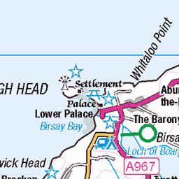
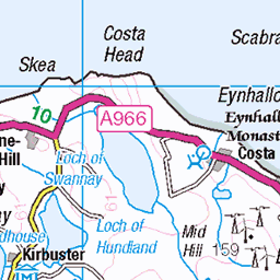
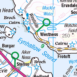
OS Map of Ward Hill
Height: 481m / 1578ft • Prominence: 481m / 1578ft • Summit : large cairn 12m W of trig point • Trip reports (hill-bagging)

Hoy | Orkney Islands-76
19-May-19 • Paul Dykes • flickr
scotland unitedkingdom hoy orkney orkneys orkneyislands islands walk hiking sea stromness 47931567472

Hoy | Orkney Islands-77
19-May-19 • Paul Dykes • flickr
scotland unitedkingdom hoy orkney orkneys orkneyislands islands walk hiking sea stromness 47931566547

Hoy | Orkney Islands-78
19-May-19 • Paul Dykes • flickr
scotland unitedkingdom hoy orkney orkneys orkneyislands islands walk hiking sea stromness 47931565647

Hoy | Orkney Islands-79
19-May-19 • Paul Dykes • flickr
scotland unitedkingdom hoy orkney orkneys orkneyislands islands walk hiking sea stromness 47931575331

Hoy | Orkney Islands-80
19-May-19 • Paul Dykes • flickr
scotland unitedkingdom hoy orkney orkneys orkneyislands islands walk hiking sea stromness 47931573806

Stone Hut, Lyness, Hoy, Orkney Islands, Scotland UK
goo.gl/maps/7N7L3QedSGW9ZQZNA" rel="noreferrer nofollow > Click here for 360° Panoramic View
29-Apr-16 • Stuart Smith. • flickr
48127963098
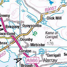
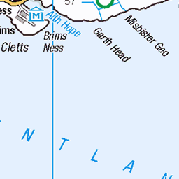
OS Map
This is OS mapping. In some areas, OpenStreetMap shows more footpaths
Spatial NI has online OSNI mapping. Click "Basemap Gallery" (4 squares icon at the top).
Now would be a good time for a cup of tea.


GPX Editor
Record map clicks
Reload map
Photos
Please tag your photos and upload them to the British and Irish Mountains group on Flickr
The other photos have been geo-tagged as on or around the summit. For less busy mountains, it can be a little hit and miss.
Hoy | Orkney Islands-76
19-May-19 • Paul Dykes • flickr
scotland unitedkingdom hoy orkney orkneys orkneyislands islands walk hiking sea stromness 47931567472
Hoy | Orkney Islands-77
19-May-19 • Paul Dykes • flickr
scotland unitedkingdom hoy orkney orkneys orkneyislands islands walk hiking sea stromness 47931566547
Hoy | Orkney Islands-78
19-May-19 • Paul Dykes • flickr
scotland unitedkingdom hoy orkney orkneys orkneyislands islands walk hiking sea stromness 47931565647
Hoy | Orkney Islands-79
19-May-19 • Paul Dykes • flickr
scotland unitedkingdom hoy orkney orkneys orkneyislands islands walk hiking sea stromness 47931575331
Hoy | Orkney Islands-80
19-May-19 • Paul Dykes • flickr
scotland unitedkingdom hoy orkney orkneys orkneyislands islands walk hiking sea stromness 47931573806
Stone Hut, Lyness, Hoy, Orkney Islands, Scotland UK
goo.gl/maps/7N7L3QedSGW9ZQZNA" rel="noreferrer nofollow > Click here for 360° Panoramic View
29-Apr-16 • Stuart Smith. • flickr
48127963098

Shetland (Orkney?) Ponies, Murra, Hoy, Orkney Islands, Scotland UK
29-Apr-16 • Stuart Smith. • flickr
7dmarkii blighty britain british canoneos7dmarkii equine explore flickrgeotaggers gbr geo:lat=5891254167 geo:lon=334217333 geotagged gps greatbritain horse hoyorkneyislandsscotland httpstudiaphotos lyness mapped murra olddart ponies pony scotland scots scottish shetlanponies stuartsmith stuartsmithstudiaphotos studiaphotos uk unitedkingdom wwwstudiaphotos 48136651813

Highland Coo, Murra, Hoy, Orkney Islands, Scotland UK
29-Apr-16 • Stuart Smith. • flickr
7dmarkii beef blighty bòghàidhealach britain british canoneos7dmarkii cattle cow explore flickrgeotaggers gbr geo:lat=5891254167 geo:lon=334217333 geotagged gps greatbritain heilancoo highlandcow hoyorkneyislandsscotland httpstudiaphotos lyness mapped murra olddart scotland scots scottish stuartsmith stuartsmithstudiaphotos studiaphotos uk unitedkingdom wwwstudiaphotos 48136619816

1549 Ward Hill (Hoy)
Steep climb up in the mist after bagging the TuMP called Round Hill with Jim Bloomer and Tricky Speirs. Orkney (1974) administrative county top, Orkney historic county top and Orkney Islands current county/UA top. Name:Ward Hill Hill number:1549 Height:481m / 1578ft Area:23: Orkney Islands Class:Ma,4,CoH,CoU, CoA Grid ref: HY 22862 02238 Summit feature:large cairn 12m W of trig point Drop:481m Col:Sea
27-May-14 • Dugswell2 • flickr
marilyn orkney hoy wardhill p481 14479297291

1549 Ward Hill (Hoy) a
Steep climb up in the mist after bagging the TuMP called Round Hill with Jim Bloomer and Tricky Speirs. Orkney (1974) administrative county top, Orkney historic county top and Orkney Islands current county/UA top. Name:Ward Hill Hill number:1549 Height:481m / 1578ft Area:23: Orkney Islands Class:Ma,4,CoH,CoU, CoA Grid ref:HY 22862 02238 Summit feature:large cairn 12m W of trig point Drop:481m Col:Sea
27-May-14 • Dugswell2 • flickr
marilyn orkney hoy trigpoint wardhill p481 14296095538

1549 Muirneag
Used track from east to the north end of Loch Dirideanthen aim for the north end of 3 lochs including Loch NicDhomhnall then make for the summit. I managed to keep my feet dry during this walk with Martin Richardson on a windy grey day. Name:Muirneag Hill number:1579 Height:248m / 814ft Area:24A: Lewis and Nearby Islands Class:Ma,2 Grid ref:NB 47965 48920 Summit feature:trig point: OS measurement Drop:170m Col:78m NB410410
22-Sep-13 • Dugswell2 • flickr
marilyn isleoflewis trigpoint muirneag p170 10270136363

1549 Muirneag 1
Used track from east to the north end of Loch Dirideanthen aim for the north end of 3 lochs including Loch NicDhomhnall then make for the summit. I managed to keep my feet dry during this walk with Martin Richardson on a windy grey day.
22-Sep-13 • Dugswell2 • flickr
marilyn isleoflewis trigpoint muirneag 10269954964


Stromness from Ward Hill, Hoy
Mamiya 6MF, Mamiya G 75mm F/3,5 L, Ektachrome E100SW, digitised by photographing the original 60mm transparency on a light pad; tethered capture in Lightroom. A view from the highest point of Orkney, Ward Hill on the island of Hoy, towards Stromness on Orkney Mainland. The ferry from Scrabster on the mainland of Scotland is arriving. 'The name "Stromness" comes from the Norse Straumrnes. Straumr refers to the strong tides that rip past the Point of Ness through Hoy Sound to the south of the town. Nes means "headland". Stromness thus means "headland protruding into the tidal stream". In Viking times the anchorage where Stromness now stands was called Hamnavoe, meaning "peaceful" or "safe harbour".' (Wikipedia) en.wikipedia.org/wiki/Stromness" rel="noreferrer nofollow en.wikipedia.org/wiki/Stromness en.wikipedia.org/wiki/Ward_Hill,_Hoy" rel="noreferrer nofollow en.wikipedia.org/wiki/Ward_Hill,_Hoy en.wikipedia.org/wiki/Hoy" rel="noreferrer nofollow en.wikipedia.org/wiki/Hoy en.wikipedia.org/wiki/Orkney" rel="noreferrer nofollow en.wikipedia.org/wiki/Orkney de.wikipedia.org/wiki/Orkney" rel="noreferrer nofollow de.wikipedia.org/wiki/Orkney
26-Jul-97 • Ed Fulton • flickr
6mf 6x6 e100sw ektachrome film hoy lightpaddigitised mamiya mamiya6mf mamiyag75mmf35l mediumformat mittelformat orkney scotland uk wardhill stromness unitedkingdom 51093388404

The clouds on Ward Hill frame the view of Scapa Flow
Mamiya 6MF, Mamiya G 75mm F/3,5 L, Ektachrome E100SW, digitised by photographing the original 60mm transparency on a light pad; tethered capture in Lightroom. A view from the highest point of Orkney, Ward Hill on the island of Hoy, towards Scapa Flow, the main naval base for the British fleet in both the First and Second World Wars. Nach dem Waffenstillstand [in 1918] wurden 74 Schiffe der deutschen Hochseeflotte in Scapa Flow interniert. Dort gab Konteradmiral Ludwig von Reuter am 21. Juni 1919 den Befehl zur Selbstversenkung der Flotte. [ . . . ] Heute liegen immer noch sieben Schiffe [ . . . ] am Meeresgrund und dienen als beliebtes Ziel für Tauchausflüge. (Wikipedia) en.wikipedia.org/wiki/Ward_Hill,_Hoy" rel="noreferrer nofollow en.wikipedia.org/wiki/Ward_Hill,_Hoy en.wikipedia.org/wiki/Hoy" rel="noreferrer nofollow en.wikipedia.org/wiki/Hoy en.wikipedia.org/wiki/Scapa_Flow" rel="noreferrer nofollow en.wikipedia.org/wiki/Scapa_Flow de.wikipedia.org/wiki/Scapa_Flow" rel="noreferrer nofollow de.wikipedia.org/wiki/Scapa_Flow de.wikipedia.org/wiki/Selbstversenkung_der_Kaiserlichen_Hochseeflotte_in_Scapa_Flow" rel="noreferrer nofollow de.wikipedia.org/wiki/Selbstversenkung_der_Kaiserlichen_H... en.wikipedia.org/wiki/Scuttling_of_the_German_fleet_at_Scapa_Flow" rel="noreferrer nofollow en.wikipedia.org/wiki/Scuttling_of_the_German_fleet_at_Sc... en.wikipedia.org/wiki/Orkney" rel="noreferrer nofollow en.wikipedia.org/wiki/Orkney de.wikipedia.org/wiki/Orkney" rel="noreferrer nofollow de.wikipedia.org/wiki/Orkney
26-Jul-97 • Ed Fulton • flickr
6mf 6x6 e100sw ektachrome film hoy lightpaddigitised mamiya mamiya6mf mediumformat mittelformat orkney scotland uk wardhill stromness unitedkingdom scapaflow 51091905015
Videos
Shooting the Hoy Hills in Orkney from across Hoy Sound! had to get my feet wet in the process thanks to leaking boots and sadly ...
Flyover the amazing Outbrecks Cottages, Cuminess Bay with views towards the Hoy Hills and the lochs of Stenness and Harray.
Come with us to this magical archipelago in the far north of Scotland. A wilderness walking holiday with us in #Orkney involves ...
Part 2 of our Orkney adventure, covering an amazing hiking trip to the Hoy Island! (Ferry from Stromness to Linksness (Hoy), Bay ...
This is Houton Orkney Ferry Terminal in Orphir, Orkney Mainland, Scotland, UK on 5/18/23. This is small ferry operation but the ...
Notes
- Data: Database of British and Irish Hills v18.2
- Maps: We use OS mapping for England, Scotland, Wales, and the Isle of Man. Sadly, Channel Islands, Northern (OSNI) and Southern Ireland (OSI) mapping isn't available online, so we use Openstreetmap.