Hills of Britain and Ireland
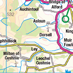
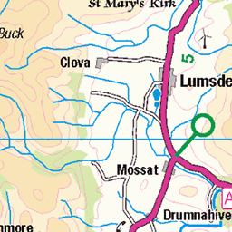
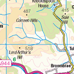
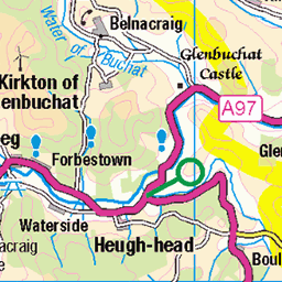
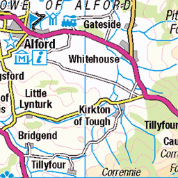
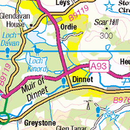
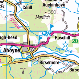
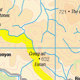
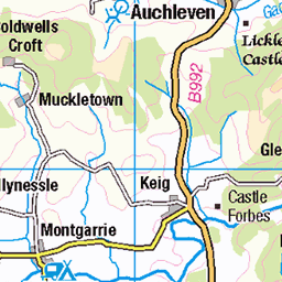
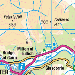
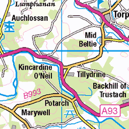
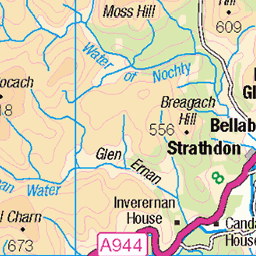
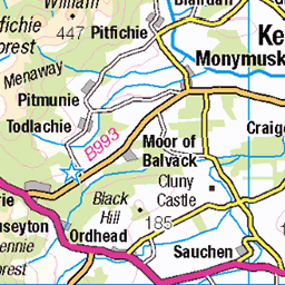
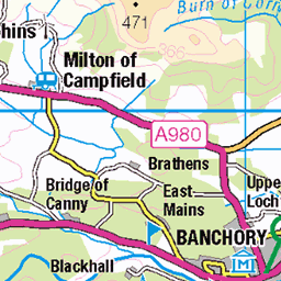
OS Map of Pressendye
Height: 619m / 2031ft • Prominence: 254m / 833ft • Summit : huge cairn/wind shelter • Trip reports (hill-bagging)

Pressendye
Looking across from the cairn to the trigpoint.
23-Sep-23 • We travel the Spaceways • flickr
53212241703

Heading back after sunset
Evening visit to Pressendye. We'd dipped on this one earlier in the year so tried a different way up today. Last time on this route was 10 years back. It was much nicer then I remembered. Sunshine through the trees and then on to the open heather hillside. Bit windy on top. We hid behind the cairn and had our tea. Very different on the way down, cold, rainy, misty and dark. I loved the contrast with the sunny way up. A nice walk in the shire.
23-Sep-23 • We travel the Spaceways • flickr
53212448910


Twilight seemed short tonight
Clouds cleared and the moon, planets and stars soon came out to play.
10-Sep-22 • We travel the Spaceways • flickr
52347675092


OS Map
This is OS mapping. In some areas, OpenStreetMap shows more footpaths
Spatial NI has online OSNI mapping. Click "Basemap Gallery" (4 squares icon at the top).
Now would be a good time for a cup of tea.

GPX Editor
Record map clicks
Reload map
Photos
Please tag your photos and upload them to the British and Irish Mountains group on Flickr
The other photos have been geo-tagged as on or around the summit. For less busy mountains, it can be a little hit and miss.
Pressendye
Looking across from the cairn to the trigpoint.
23-Sep-23 • We travel the Spaceways • flickr
53212241703
Heading back after sunset
Evening visit to Pressendye. We'd dipped on this one earlier in the year so tried a different way up today. Last time on this route was 10 years back. It was much nicer then I remembered. Sunshine through the trees and then on to the open heather hillside. Bit windy on top. We hid behind the cairn and had our tea. Very different on the way down, cold, rainy, misty and dark. I loved the contrast with the sunny way up. A nice walk in the shire.
23-Sep-23 • We travel the Spaceways • flickr
53212448910
Twilight seemed short tonight
Clouds cleared and the moon, planets and stars soon came out to play.
10-Sep-22 • We travel the Spaceways • flickr
52347675092

Summit of Pressendye
We're now just halfway through the walk and have made the summit of Pressendye, with the Cairn and trig. point. Now it's just the descent and back to Tarland. Pressendye is just a small Graham of 620 meters (2034 feet), but a 15 Km (9 mile) circuit definitely stretched the legs.
12-Jul-20 • steve_whitmarsh • flickr
aberdeenshire scotland landscape summit sky green topic rockpaper 50137489206

Pressendye Trig Point
The trig point at the summit of Pressendye with the hills and Highlands beyond. Pressendye is just a small Graham of 620 meters (2034 feet), but a 15 Km (9 mile) circuit definitely stretched the legs.
12-Jul-20 • steve_whitmarsh • flickr
aberdeenshire scotland landscape summit cairn sky blue topic trigonometricmonument 50137723572

Admiral in the Heather
A Red Adirmal (Vanessa atalanta) butterfly sits among the blooming bell heather on the descent from Pressendye on our way back to Tarland. Pressendye is just a small Graham of 620 meters (2034 feet), but a 15 Km (9 mile) circuit definitely stretched the legs.
12-Jul-20 • steve_whitmarsh • flickr
aberdeenshire scotland animal insect wildlife nature butterfly redadmiral flowers purple heather topic 50140870356

Lonesome Pine
The slopes of Pressendye are covered in heather and occasionally the Pine trees manage to take a hold. Pressendye is just a small Graham of 620 meters (2034 feet), but a 15 Km (9 mile) circuit definitely stretched the legs.
12-Jul-20 • steve_whitmarsh • flickr
aberdeenshire scotland landscape trees sky blue topic 50140870151
Videos
A fast paced red mountain bike trail at Tarland that comes after the call me Chris trail. Great fun! Check out my Tarland playlist for ...
Kincardine O'Neil Village to Dess Waterfall Walk, Scotland Countryside 4K. The video was recorded on location by DJI Pocket 2 ...
Good fun at Aboyne on the Chutney trail on 12th Feb 2022. One of the milder trails but its fast and fun! #mtbscotland #mtb ...
The red flow trail Call Me Chris from Tarland. Please check out the other trails from this place in my Tarland Playlist which will be ...
Short video of Matthew and I riding the Tarland MTB trails in Aboyne.
Notes
- Data: Database of British and Irish Hills v18.2
- Maps: We use OS mapping for England, Scotland, Wales, and the Isle of Man. Sadly, Channel Islands, Northern (OSNI) and Southern Ireland (OSI) mapping isn't available online, so we use Openstreetmap.