Hills of Britain and Ireland
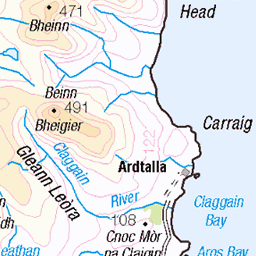
OS Map of Cnoc an Ime
Height: 303m / 994ft • Prominence: 189m / 620ft • Summit : small pile of stones • Trip reports (hill-bagging)

10531 - Craig Mor
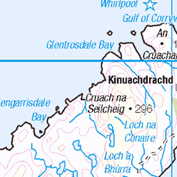
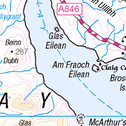
NR589794, LR61. HISTORY Pillar completed 13th June 1959 costing £24.13s.3d. Computed as secondary triangulation station NM52/49 within the Mull secondary block, and levelled to second class precision during 1960. This pillar station was last maintained by the Ordnance Survey in May 1979. SITE VISIT Overall approach from the northeast. Parked on hard ground off the passing place on the SE side of the A846 at NR599798. Parking by the derelict cottage would have meant leaving the car on soft sloping ground below road level or occupying a passing place. Walked the road to just south of the bridge at NR598797 and turned right up the woods. These woods stand on very boggy ground so the route was never going to be direct. Turned left at NR596799 before the burn and continued SW staying fairly level to NR594796. Out of the woods onto the open hills at NR591797. Continued upwards and crossed the burn (Sruthan an Uruisge) just below Loch Losguinn for the final ascent to the trig column on Clach an Roin. The Vanessa is in good condition. The spider retains its original OS centre cap with raised large narrow letters. The flush bracket faces south, compass measurement 162°. Vented through the right sight holes. The full 360° panorama is overtopped in the northwest by the true summit. Descended following the north side of Sruthan an Uruisge burn to level boggy ground at NR595795 turned left to avoid the stagnant bog then back on course down to the A846 at NR596794. Walked the A846 back to the car, using wet hanging moss from the dykes to remove mud. Photographed: 15th May 2024, GRP. ═════════════════════════ Interactive index: www.google.com/maps/d/viewer?mid=1arx2Qmo5mVeVUJA2lzVG_uzbYPW59ffh&ll=55.947480,-5.862097&z=11" rel="noreferrer nofollow Google My Maps ═════════════════════════ Neighbouring Triangulation Pillars www.flickr.com/photos/13460108@N06/53753463851/in/album-72157631838876970/ 10500 - Leac Fhola : 2.34 miles to the SW www.flickr.com/photos/13460108@N06/53753654578/in/album-72157631838876970/ 10481 - Beinn Sgaillinish : 3.46 miles to the NE 10494 - Cruib : 3.52 miles to the NW www.flickr.com/photos/13460108@N06/52922867414/in/album-72157631821839859/ S8990 - Ardfernal : 5.12 miles to the south 10533 - Tom Uaine : 5.74 miles to the NW www.flickr.com/photos/13460108@N06/52922127932/in/album-72157631347423092/ S3680 - Jura : 6.34 miles to the SW www.flickr.com/photos/13460108@N06/53753880935/in/album-72157631838876970/ 10509 - Carn A` Lomain : 6.72 miles to the NE 10506 - Beinn Bhreac (Jura) : 7.12 miles to the north ═════════════════════════
28-May-24 • Graeme5015 • flickr
osbm10531 10531 lagg jura 53753655983


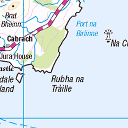
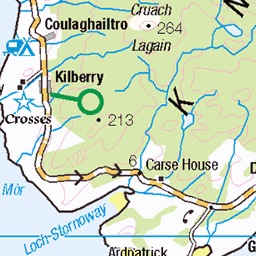
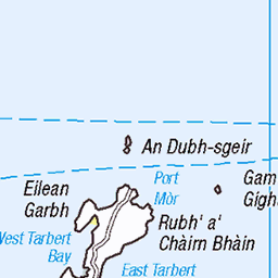
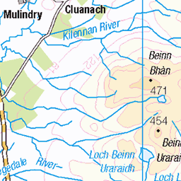
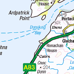
OS Map
This is OS mapping. In some areas, OpenStreetMap shows more footpaths
Spatial NI has online OSNI mapping. Click "Basemap Gallery" (4 squares icon at the top).
Now would be a good time for a cup of tea.


GPX Editor
Record map clicks
Reload map
Photos
Please tag your photos and upload them to the British and Irish Mountains group on Flickr
The other photos have been geo-tagged as on or around the summit. For less busy mountains, it can be a little hit and miss.
10531 - Craig Mor
NR589794, LR61. HISTORY Pillar completed 13th June 1959 costing £24.13s.3d. Computed as secondary triangulation station NM52/49 within the Mull secondary block, and levelled to second class precision during 1960. This pillar station was last maintained by the Ordnance Survey in May 1979. SITE VISIT Overall approach from the northeast. Parked on hard ground off the passing place on the SE side of the A846 at NR599798. Parking by the derelict cottage would have meant leaving the car on soft sloping ground below road level or occupying a passing place. Walked the road to just south of the bridge at NR598797 and turned right up the woods. These woods stand on very boggy ground so the route was never going to be direct. Turned left at NR596799 before the burn and continued SW staying fairly level to NR594796. Out of the woods onto the open hills at NR591797. Continued upwards and crossed the burn (Sruthan an Uruisge) just below Loch Losguinn for the final ascent to the trig column on Clach an Roin. The Vanessa is in good condition. The spider retains its original OS centre cap with raised large narrow letters. The flush bracket faces south, compass measurement 162°. Vented through the right sight holes. The full 360° panorama is overtopped in the northwest by the true summit. Descended following the north side of Sruthan an Uruisge burn to level boggy ground at NR595795 turned left to avoid the stagnant bog then back on course down to the A846 at NR596794. Walked the A846 back to the car, using wet hanging moss from the dykes to remove mud. Photographed: 15th May 2024, GRP. ═════════════════════════ Interactive index: www.google.com/maps/d/viewer?mid=1arx2Qmo5mVeVUJA2lzVG_uzbYPW59ffh&ll=55.947480,-5.862097&z=11" rel="noreferrer nofollow Google My Maps ═════════════════════════ Neighbouring Triangulation Pillars www.flickr.com/photos/13460108@N06/53753463851/in/album-72157631838876970/ 10500 - Leac Fhola : 2.34 miles to the SW www.flickr.com/photos/13460108@N06/53753654578/in/album-72157631838876970/ 10481 - Beinn Sgaillinish : 3.46 miles to the NE 10494 - Cruib : 3.52 miles to the NW www.flickr.com/photos/13460108@N06/52922867414/in/album-72157631821839859/ S8990 - Ardfernal : 5.12 miles to the south 10533 - Tom Uaine : 5.74 miles to the NW www.flickr.com/photos/13460108@N06/52922127932/in/album-72157631347423092/ S3680 - Jura : 6.34 miles to the SW www.flickr.com/photos/13460108@N06/53753880935/in/album-72157631838876970/ 10509 - Carn A` Lomain : 6.72 miles to the NE 10506 - Beinn Bhreac (Jura) : 7.12 miles to the north ═════════════════════════
28-May-24 • Graeme5015 • flickr
osbm10531 10531 lagg jura 53753655983


Videos
Tour Scotland travel video clip, with Scottish music, of Barnhill Farmhouse on ancestry, genealogy, history visit to Island Of Jura, ...
Notes
- Data: Database of British and Irish Hills v18.2
- Maps: We use OS mapping for England, Scotland, Wales, and the Isle of Man. Sadly, Channel Islands, Northern (OSNI) and Southern Ireland (OSI) mapping isn't available online, so we use Openstreetmap.