Hills of Britain and Ireland
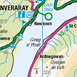
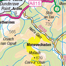
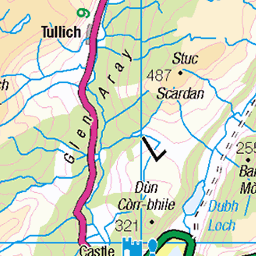
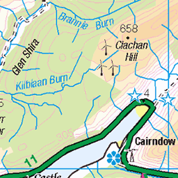
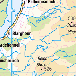
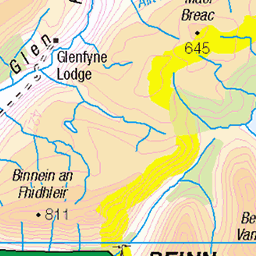
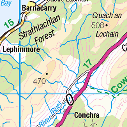
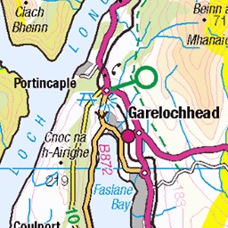
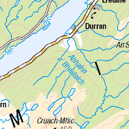
OS Map of Beinn Lagan
Height: 465m / 1526ft • Prominence: 243m / 797ft • Summit : ground within 2m of trig point • Trip reports (hill-bagging)


Looking To Glenbranter From Invernoaden
01-Jun-19 • Click And Pray • flickr
managedbyclickandpraysflickrmanagr glenbranter invernoaden nopeople argyll scotland forest woodland remote hills above glenbranterinvernoadennopeopleargyllscotlandforestwoodlandremotehillsabove 48039819146

Above Invernoaden
Video: www.youtube.com/watch?v=5Pz4ko5LPjs" rel="noreferrer nofollow www.youtube.com/watch?v=5Pz4ko5LPjs
01-Jun-19 • Click And Pray • flickr
managedbyclickandpraysflickrmanagr n glenbranterargyllscotland 47996501748

Old And New
Forestry is big business in Argyll, a business that gives us lots of excellent forestry trails to explore. Old piles of logs in amongst the new trees are therefore a common sight.
25-May-19 • Click And Pray • flickr
managedbyclickandpraysflickrmanagr nopeople argyll scotland invernoaden tree logs bluebell wildflower forest woodland ferns remote idyllic tranquility nopeopleargyllscotlandinvernoadentreelogsbluebellwildflowerforestwoodlandfernsremoteidyllictranquility 48002317311
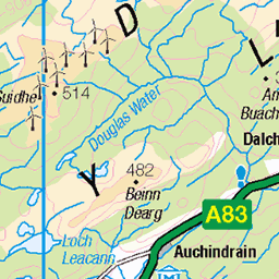
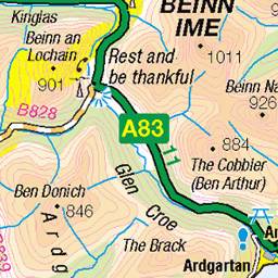
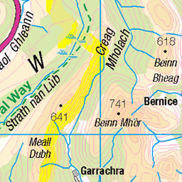
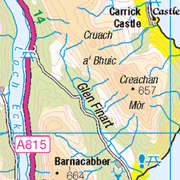
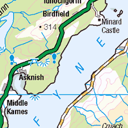
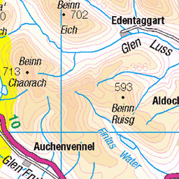
OS Map
This is OS mapping. In some areas, OpenStreetMap shows more footpaths
Spatial NI has online OSNI mapping. Click "Basemap Gallery" (4 squares icon at the top).
Now would be a good time for a cup of tea.
GPX Editor
Record map clicks
Reload map
Photos
Please tag your photos and upload them to the British and Irish Mountains group on Flickr
The other photos have been geo-tagged as on or around the summit. For less busy mountains, it can be a little hit and miss.
Looking To Glenbranter From Invernoaden
01-Jun-19 • Click And Pray • flickr
managedbyclickandpraysflickrmanagr glenbranter invernoaden nopeople argyll scotland forest woodland remote hills above glenbranterinvernoadennopeopleargyllscotlandforestwoodlandremotehillsabove 48039819146
Above Invernoaden
Video: www.youtube.com/watch?v=5Pz4ko5LPjs" rel="noreferrer nofollow www.youtube.com/watch?v=5Pz4ko5LPjs
01-Jun-19 • Click And Pray • flickr
managedbyclickandpraysflickrmanagr n glenbranterargyllscotland 47996501748
Old And New
Forestry is big business in Argyll, a business that gives us lots of excellent forestry trails to explore. Old piles of logs in amongst the new trees are therefore a common sight.
25-May-19 • Click And Pray • flickr
managedbyclickandpraysflickrmanagr nopeople argyll scotland invernoaden tree logs bluebell wildflower forest woodland ferns remote idyllic tranquility nopeopleargyllscotlandinvernoadentreelogsbluebellwildflowerforestwoodlandfernsremoteidyllictranquility 48002317311

Towards The Mist
One of the many tracks around the Strachur/Glanbranter area
09-Jul-17 • Click And Pray • flickr
managedbyclickandpraysflickrmanagr glenbranter track scotland argyll forest foresttrack horizontal landscape woodland trees path mist intothedistance strachur glenbrantertrackscotlandargyllforestforesttrackhorizontallandscapewoodlandtreespathmistintothedistancestrachurgbr 35023144194

Into The Mist
One of the many tracks around the Strachur/Glenbranter area
09-Jul-17 • Click And Pray • flickr
managedbyclickandpraysflickrmanagr glenbranter track scotland argyll forest foresttrack horizontal landscape woodland trees path mist intothedistance strachur glenbrantertrackscotlandargyllforestforesttrackhorizontallandscapewoodlandtreespathmistintothedistancestrachurgbr 35578489180

Long And Winding Road
One of the many tracks around the Strachur/Glenbranter area
09-Jul-17 • Click And Pray • flickr
managedbyclickandpraysflickrmanagr glenbranter track scotland argyll forest foresttrack horizontal landscape woodland trees path mist intothedistance strachur hills glenbrantertrackscotlandargyllforestforesttrackhorizontallandscapewoodlandtreespathmistintothedistancestrachurhillsgbr 36032092165

Videos
Driving through the Cowal Peninsula, Argyll, Scotland, we visit two historical sites at Strachur and Kilmorie which are on the ...
Strachur Smiddy fell out of use in the 1950s. In the 1990s a group of local people worked to turn it into a tourist attraction and ...
drone flight at strachur.
Strachur Smiddy has a long history, the first recorded reference to it being in 1791, and it continued to function until it closed in the ...
Notes
- Data: Database of British and Irish Hills v18.2
- Maps: We use OS mapping for England, Scotland, Wales, and the Isle of Man. Sadly, Channel Islands, Northern (OSNI) and Southern Ireland (OSI) mapping isn't available online, so we use Openstreetmap.