Hills of Britain and Ireland
OS Map of Griomasaigh
Height: 30m / 98ft • Prominence: 30m / 98ft • Summit : knoll • Trip reports (hill-bagging)

Grimsay Boat Museum
Ceann na h-Àirigh www.facebook.com/GrimsayBoatMuseum" rel="noreferrer nofollow www.facebook.com/GrimsayBoatMuseum www.grimsay.org/" rel="noreferrer nofollow www.grimsay.org/
27-Sep-23 • Prospector73 • flickr
53272534729

Grimsay Boat Museum
Ceann na h-Àirigh www.grimsay.org/" rel="noreferrer nofollow www.grimsay.org/
27-Sep-23 • Prospector73 • flickr
53271288777

Grimsay Boat Museum
Ceann na h-Àirigh www.grimsay.org/" rel="noreferrer nofollow www.grimsay.org/
27-Sep-23 • Prospector73 • flickr
53272545279


Grimsay Boat Museum
Ceann na h-Àirigh www.grimsay.org/" rel="noreferrer nofollow www.grimsay.org/
27-Sep-23 • Prospector73 • flickr
53271292622

Wheatear
06-Jun-23 • Shane Jones • flickr
wheatear bird wildlife nature nikon z9 500mmf4 tc14eii 52975811597
OS Map
This is OS mapping. In some areas, OpenStreetMap shows more footpaths
Spatial NI has online OSNI mapping. Click "Basemap Gallery" (4 squares icon at the top).
Now would be a good time for a cup of tea.
GPX Editor
Record map clicks
Reload map
Photos
Please tag your photos and upload them to the British and Irish Mountains group on Flickr
The other photos have been geo-tagged as on or around the summit. For less busy mountains, it can be a little hit and miss.
Grimsay Boat Museum
Ceann na h-Àirigh www.facebook.com/GrimsayBoatMuseum" rel="noreferrer nofollow www.facebook.com/GrimsayBoatMuseum www.grimsay.org/" rel="noreferrer nofollow www.grimsay.org/
27-Sep-23 • Prospector73 • flickr
53272534729
Grimsay Boat Museum
Ceann na h-Àirigh www.grimsay.org/" rel="noreferrer nofollow www.grimsay.org/
27-Sep-23 • Prospector73 • flickr
53271288777
Grimsay Boat Museum
Ceann na h-Àirigh www.grimsay.org/" rel="noreferrer nofollow www.grimsay.org/
27-Sep-23 • Prospector73 • flickr
53272545279
Grimsay Boat Museum
Ceann na h-Àirigh www.grimsay.org/" rel="noreferrer nofollow www.grimsay.org/
27-Sep-23 • Prospector73 • flickr
53271292622
Wheatear
06-Jun-23 • Shane Jones • flickr
wheatear bird wildlife nature nikon z9 500mmf4 tc14eii 52975811597

Wheatear
06-Jun-23 • Shane Jones • flickr
wheatear bird wildlife nature nikon z9 500mmf4 tc14eii northuist 53048316843

12789 Griomasaigh
12-Jun-22 • Dugswell2 • flickr
islandgrimsaygriomasaigh griomasaigh p30 tump sib 52170062610

12789 Griomasaigh b
12-Jun-22 • Dugswell2 • flickr
islandgrimsaygriomasaigh griomasaigh p30 tump sib 52170064825

12789 Griomasaigh c
12-Jun-22 • Dugswell2 • flickr
islandgrimsaygriomasaigh griomasaigh p30 tump sib 52170065950

12789 Griomasaigh a
Parked off road near the mast. Then over damp moorland to visit the 5 most likely summits. Name:Griomasaigh Hill number:12789 Height:30m / 98ft Parent (Ma):none RHB Section:24C: North Uist, South Uist and Nearby Islands County/UA:Na h-Eileanan Siar [Western Isles] (UA) Island:Mono Tump island Maritime area:Around Grimsay & Ronay Watershed:Long Island Class:Tump (0-99m), SIB Grid ref:NF 86372 56789 Summit feature:knoll Drop:30m Col:Sea Observations:there are four alternative summits at NF 86031 56969, NF 86273 56932, NF 86245 56577 and NF 86501 56549 Survey:Abney level
12-Jun-22 • Dugswell2 • flickr
islandgrimsaygriomasaigh griomasaigh p30 tump sib 52169591378
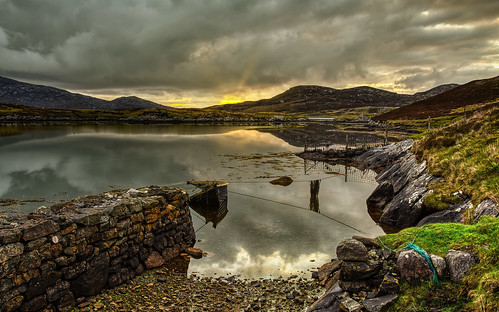
Grimsay, Outer Hebrides 6D8638
The calm at dawn after the storm. The old harbour at Bàgh Mòr (Big Bay) with stone pier where fish were landed before the modern Kallin harbour was built in 1985. Located on the Isle of Grimsay, between North Uist and Benbecula in the Outer Hebrides, Scotland. Grimsay is linked by the single track North Ford causeway that spans between North Uist and Benbecula which was opened by the Queen Mother in September 1960. The sun is rising over the Isle of Ronay in the distance.
28-May-22 • ElizFlickr • flickr
grimsay isle island harbour hebrides outerhebrides baghmor scotland 52880033966

Bella, Morag and Morag
16-May-16 • Donald Morrison • flickr
grimsay northuist people friends community 51887398699

Gilleasbaig
16-May-16 • Donald Morrison • flickr
grimsay northuist people friends community 51887070056
Videos
None found
Notes
- Data: Database of British and Irish Hills v18.2
- Maps: We use OS mapping for England, Scotland, Wales, and the Isle of Man. Sadly, Channel Islands, Northern (OSNI) and Southern Ireland (OSI) mapping isn't available online, so we use Openstreetmap.