Hills of Britain and Ireland
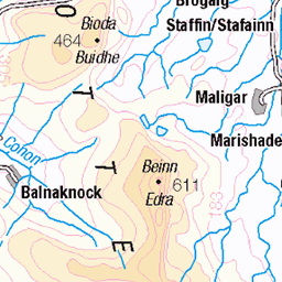
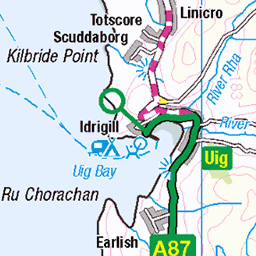
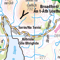
OS Map of Sithean Bhealaich Chumhaing (Sithean a' Bhealaich Chumhaing)
Height: 393m / 1289ft • Prominence: 235m / 771ft • Summit : no feature 2m N of trig point • Trip reports (hill-bagging)


Storr
Leaving the campsite of the previous night, off the Trotternish Ridge, continuing the Skye Trail to Storr and then onto Portree. Looking back at Storr from even further away.
skyetrail skye island highlands aghàidhealtachd anteileansgitheanach hebrides naheileananastaigh trotternish ridge storr 53723302410

Storr
Leaving the campsite of the previous night, off the Trotternish Ridge, continuing the Skye Trail to Storr and then onto Portree.
skyetrail skye island highlands aghàidhealtachd anteileansgitheanach hebrides naheileananastaigh trotternish ridge storr portree 53723083073

1232 Sithean Bhealaich Chumhaing
Name:Sithean Bhealaich Chumhaing [Sithean a' Bhealaich Chumhaing] Hill number:1232 Height:393m / 1289ft RHB Section:17A: North Skye and Raasay County/UA:Highland (UA) Island:Skye Maritime area:Skye & surrounding islands Class:Marilyn, Hump, Tump (300-399m), Yeaman Grid ref:NG 50897 46616 Summit feature:no feature 2m N of trig point Drop:235m Col:158m NG494482
01-Jun-23 • Dugswell2 • flickr
isleofskye sitheanbhealaichchumhaing p235 marilyn hump tump yeaman 52948718682

photo
11-Jul-21 • hikinginlondon • flickr
theskyetrailachallengingbackpackingroute portree scotland unitedkingdom hikinginlondon theskyetrail trotternishridge flodigarry rubhahunish challenging cuillin drone4k hillwalkers coastalpath skyetrail solohiking hikingalone hikinggear backpack extremehikingtrails skyetrailscotland skyetrailhike thetrailhunter oldmanofstorr skyetrailthruhike sligachan theskyetrail|scotland|4k skye hikeisleofskye isleofskyescotland isleofskye saturdaywalkersclub 51330766332

photo
11-Jul-21 • hikinginlondon • flickr
theskyetrailachallengingbackpackingroute portree scotland unitedkingdom hikinginlondon theskyetrail trotternishridge flodigarry rubhahunish challenging cuillin drone4k hillwalkers coastalpath skyetrail solohiking hikingalone hikinggear backpack extremehikingtrails skyetrailscotland skyetrailhike thetrailhunter oldmanofstorr skyetrailthruhike sligachan theskyetrail|scotland|4k skye hikeisleofskye isleofskyescotland isleofskye saturdaywalkersclub 51330770617
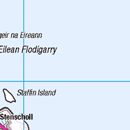
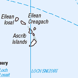
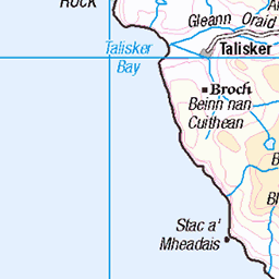
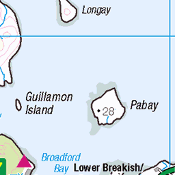
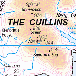
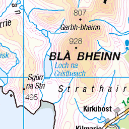
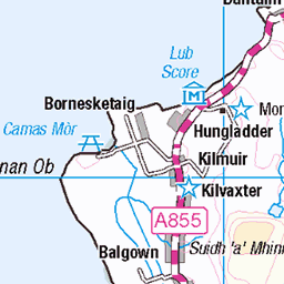
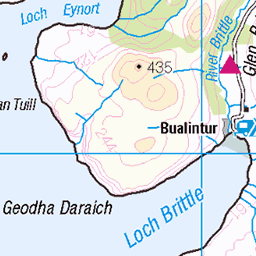
OS Map
This is OS mapping. In some areas, OpenStreetMap shows more footpaths
Spatial NI has online OSNI mapping. Click "Basemap Gallery" (4 squares icon at the top).
Now would be a good time for a cup of tea.


GPX Editor
Record map clicks
Reload map
Photos
Please tag your photos and upload them to the British and Irish Mountains group on Flickr
The other photos have been geo-tagged as on or around the summit. For less busy mountains, it can be a little hit and miss.
Storr
Leaving the campsite of the previous night, off the Trotternish Ridge, continuing the Skye Trail to Storr and then onto Portree. Looking back at Storr from even further away.
skyetrail skye island highlands aghàidhealtachd anteileansgitheanach hebrides naheileananastaigh trotternish ridge storr 53723302410
Storr
Leaving the campsite of the previous night, off the Trotternish Ridge, continuing the Skye Trail to Storr and then onto Portree.
skyetrail skye island highlands aghàidhealtachd anteileansgitheanach hebrides naheileananastaigh trotternish ridge storr portree 53723083073
1232 Sithean Bhealaich Chumhaing
Name:Sithean Bhealaich Chumhaing [Sithean a' Bhealaich Chumhaing] Hill number:1232 Height:393m / 1289ft RHB Section:17A: North Skye and Raasay County/UA:Highland (UA) Island:Skye Maritime area:Skye & surrounding islands Class:Marilyn, Hump, Tump (300-399m), Yeaman Grid ref:NG 50897 46616 Summit feature:no feature 2m N of trig point Drop:235m Col:158m NG494482
01-Jun-23 • Dugswell2 • flickr
isleofskye sitheanbhealaichchumhaing p235 marilyn hump tump yeaman 52948718682
photo
11-Jul-21 • hikinginlondon • flickr
theskyetrailachallengingbackpackingroute portree scotland unitedkingdom hikinginlondon theskyetrail trotternishridge flodigarry rubhahunish challenging cuillin drone4k hillwalkers coastalpath skyetrail solohiking hikingalone hikinggear backpack extremehikingtrails skyetrailscotland skyetrailhike thetrailhunter oldmanofstorr skyetrailthruhike sligachan theskyetrail|scotland|4k skye hikeisleofskye isleofskyescotland isleofskye saturdaywalkersclub 51330766332
photo
11-Jul-21 • hikinginlondon • flickr
theskyetrailachallengingbackpackingroute portree scotland unitedkingdom hikinginlondon theskyetrail trotternishridge flodigarry rubhahunish challenging cuillin drone4k hillwalkers coastalpath skyetrail solohiking hikingalone hikinggear backpack extremehikingtrails skyetrailscotland skyetrailhike thetrailhunter oldmanofstorr skyetrailthruhike sligachan theskyetrail|scotland|4k skye hikeisleofskye isleofskyescotland isleofskye saturdaywalkersclub 51330770617

photo
11-Jul-21 • hikinginlondon • flickr
theskyetrailachallengingbackpackingroute portree scotland unitedkingdom hikinginlondon theskyetrail trotternishridge flodigarry rubhahunish challenging cuillin drone4k hillwalkers coastalpath skyetrail solohiking hikingalone hikinggear backpack extremehikingtrails skyetrailscotland skyetrailhike thetrailhunter oldmanofstorr skyetrailthruhike sligachan theskyetrail|scotland|4k skye hikeisleofskye isleofskyescotland isleofskye saturdaywalkersclub 51332233424

photo
11-Jul-21 • hikinginlondon • flickr
theskyetrailachallengingbackpackingroute portree scotland unitedkingdom hikinginlondon theskyetrail trotternishridge flodigarry rubhahunish challenging cuillin drone4k hillwalkers coastalpath skyetrail solohiking hikingalone hikinggear backpack extremehikingtrails skyetrailscotland skyetrailhike thetrailhunter oldmanofstorr skyetrailthruhike sligachan theskyetrail|scotland|4k skye hikeisleofskye isleofskyescotland isleofskye saturdaywalkersclub 51332243979

photo
11-Jul-21 • hikinginlondon • flickr
theskyetrailachallengingbackpackingroute portree scotland unitedkingdom hikinginlondon theskyetrail trotternishridge flodigarry rubhahunish challenging cuillin drone4k hillwalkers coastalpath skyetrail solohiking hikingalone hikinggear backpack extremehikingtrails skyetrailscotland skyetrailhike thetrailhunter oldmanofstorr skyetrailthruhike sligachan theskyetrail|scotland|4k skye hikeisleofskye isleofskyescotland isleofskye saturdaywalkersclub 51330790227

photo
11-Jul-21 • hikinginlondon • flickr
theskyetrailachallengingbackpackingroute portree scotland unitedkingdom hikinginlondon theskyetrail trotternishridge flodigarry rubhahunish challenging cuillin drone4k hillwalkers coastalpath skyetrail solohiking hikingalone hikinggear backpack extremehikingtrails skyetrailscotland skyetrailhike thetrailhunter oldmanofstorr skyetrailthruhike sligachan theskyetrail|scotland|4k skye hikeisleofskye isleofskyescotland isleofskye saturdaywalkersclub 51331527401

photo
11-Jul-21 • hikinginlondon • flickr
theskyetrailachallengingbackpackingroute portree scotland unitedkingdom hikinginlondon theskyetrail trotternishridge flodigarry rubhahunish challenging cuillin drone4k hillwalkers coastalpath skyetrail solohiking hikingalone hikinggear backpack extremehikingtrails skyetrailscotland skyetrailhike thetrailhunter oldmanofstorr skyetrailthruhike sligachan theskyetrail|scotland|4k skye hikeisleofskye isleofskyescotland isleofskye saturdaywalkersclub 51330799912
![1232 Sithean Bhealaich Chumhaing [Sithean a' Bhealaich Chumhaing]](https://live.staticflickr.com/65535/50318531078_bf6d292f29.jpg)
1232 Sithean Bhealaich Chumhaing [Sithean a' Bhealaich Chumhaing]
Easy walk from road to the west as weather improved during afternoon. Name:Sithean Bhealaich Chumhaing [Sithean a' Bhealaich Chumhaing] Hill number:1232 Height:393m / 1289ft RHB Section:17A: North Skye and Raasay County/UA:Highland (UA) Island:Skye Maritime area:Skye & surrounding islands Class:Marilyn, Hump, Tump (300-399m), Yeaman Grid ref:NG 50897 46616 Summit feature:no feature 2m N of trig point Drop:235m Col:158m NG494482
02-Jun-11 • Dugswell2 • flickr
sitheanbhealaichchumhaingsitheanabhealaichchumhaing trigpoint marilyn hump yeaman p235 tump 50318531078
![1232 Sithean Bhealaich Chumhaing [Sithean a' Bhealaich Chumhaing] a](https://live.staticflickr.com/65535/50318532298_b11bc48916.jpg)
1232 Sithean Bhealaich Chumhaing [Sithean a' Bhealaich Chumhaing] a
02-Jun-11 • Dugswell2 • flickr
trigpoint marilyn hump yeaman p235 tump sitheanbhealaichchumhaingsitheanabhealaichchumhaing 50318532298
Videos
None found
Notes
- Data: Database of British and Irish Hills v18.2
- Maps: We use OS mapping for England, Scotland, Wales, and the Isle of Man. Sadly, Channel Islands, Northern (OSNI) and Southern Ireland (OSI) mapping isn't available online, so we use Openstreetmap.