Hills of Britain and Ireland
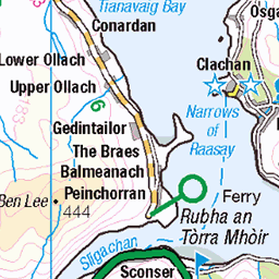
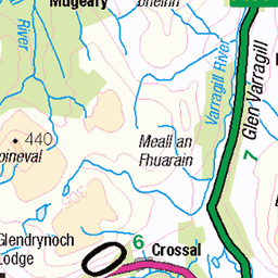
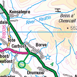
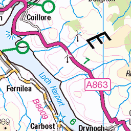
OS Map of Dun Caan
Height: 444m / 1457ft • Prominence: 444m / 1457ft • Summit : rock 13m SE of trig point • Trip reports (hill-bagging)

The Final Stretch
Having emerged from "Rowan Gully" I was met with a steep grassy slope for the final 500 feet or so to Dun Caan's summit. A line to the right of the crags found a nice grassy rake through those rocks to the top.
20-May-24 • ARG_Flickr • flickr
hallaigduncaanwalk 53784980952

Not A Cuckoo
I'd already seen one eagle fly by in front of me being mobbed by a couple of local corvids. Another one appeared as I was about half way up the grassy slope to Dun Caan. Much easier to photograph than the many cuckoos sounding off and scooting by around the hill.
20-May-24 • ARG_Flickr • flickr
hallaigduncaanwalk 53786133478

Pots And Gulls
Broadford registered BRD477 Speedwell sorting out the pots whilst the gulls look for a bit of spillage.
20-May-24 • ARG_Flickr • flickr
hallaigduncaanwalk 53788223524

Looking Down, Looking Up
Another boat seen from Dun Caan this time a small cruise vessel - Emma Jane. The passengers were looking up presumably to the eagles that I was seeing from Dun Caan.
20-May-24 • ARG_Flickr • flickr
hallaigduncaanwalk 53786966057

Liathach Beyond Applecross Bay
One of Torridon's mighty Munros seen from Dun Caan's summit - a distance of about twenty five miles.
20-May-24 • ARG_Flickr • flickr
hallaigduncaanwalk 53787907926

Storr's Rocks
The sunshine and shadow highlighted the rockery that is the Storr over on Skye. The balanced pinnacle of the Old Man of Storr is below and to the right of the final cleft on the right hand side of The Storr's rocky face.
20-May-24 • ARG_Flickr • flickr
hallaigduncaanwalk 53786966027
OS Map
This is OS mapping. In some areas, OpenStreetMap shows more footpaths
Spatial NI has online OSNI mapping. Click "Basemap Gallery" (4 squares icon at the top).
Now would be a good time for a cup of tea.
GPX Editor
Record map clicks
Reload map
Photos
Please tag your photos and upload them to the British and Irish Mountains group on Flickr
The other photos have been geo-tagged as on or around the summit. For less busy mountains, it can be a little hit and miss.
The Final Stretch
Having emerged from "Rowan Gully" I was met with a steep grassy slope for the final 500 feet or so to Dun Caan's summit. A line to the right of the crags found a nice grassy rake through those rocks to the top.
20-May-24 • ARG_Flickr • flickr
hallaigduncaanwalk 53784980952
Not A Cuckoo
I'd already seen one eagle fly by in front of me being mobbed by a couple of local corvids. Another one appeared as I was about half way up the grassy slope to Dun Caan. Much easier to photograph than the many cuckoos sounding off and scooting by around the hill.
20-May-24 • ARG_Flickr • flickr
hallaigduncaanwalk 53786133478
Pots And Gulls
Broadford registered BRD477 Speedwell sorting out the pots whilst the gulls look for a bit of spillage.
20-May-24 • ARG_Flickr • flickr
hallaigduncaanwalk 53788223524
Looking Down, Looking Up
Another boat seen from Dun Caan this time a small cruise vessel - Emma Jane. The passengers were looking up presumably to the eagles that I was seeing from Dun Caan.
20-May-24 • ARG_Flickr • flickr
hallaigduncaanwalk 53786966057
Liathach Beyond Applecross Bay
One of Torridon's mighty Munros seen from Dun Caan's summit - a distance of about twenty five miles.
20-May-24 • ARG_Flickr • flickr
hallaigduncaanwalk 53787907926
Storr's Rocks
The sunshine and shadow highlighted the rockery that is the Storr over on Skye. The balanced pinnacle of the Old Man of Storr is below and to the right of the final cleft on the right hand side of The Storr's rocky face.
20-May-24 • ARG_Flickr • flickr
hallaigduncaanwalk 53786966027

Across The Inner Sound
The sands of Applecross Bay to the right with the Torridon hills in the distance. The sandy bay to the left of centre is near to a military installation possibly related to the submarines that use the channel.
20-May-24 • ARG_Flickr • flickr
hallaigduncaanwalk 53788121748

Alternative Ending
After over an hour on the summit of Dun Caan enjoying the sunshine and the views I headed back to Inverarnish. Rather than take the "tourist path" to the car and getting a lift I decided to follow a footpath marked on the map. It headed below the line of crags and alongside the loch and was, for the most part, dry and well defined.
20-May-24 • ARG_Flickr • flickr
hallaigduncaanwalk 53789258812

Four Spotted Chaser
Between the main path off Dun Caan and the old path to Inverarnish was an area of boggy ground. The silver lining of the squelch was seeing a few dragonflies.
20-May-24 • ARG_Flickr • flickr
hallaigduncaanwalk 53789258797

Dun Caan From Loch na Mna
The secondary vent of the old volcano was also in view from the loch. I continued down to Inverarnish accompanied by the "earworm" of the Muppets Mah Nà Mah Nà song!
20-May-24 • ARG_Flickr • flickr
hallaigduncaanwalk 53789258722

1227 Dun Caan
03-Jun-11 • Dugswell2 • flickr
duncaan raasay p444 sib tump marilyn hump yeaman 50319404742

1227 Dun Caan a
Jonathan Woods' vehicle with Chris Watson & Jim Bloomer via the track from the minor road to NW, very scenic. Name:Dun Caan Hill number:1227 Height:444m / 1457ft RHB Section:17A: North Skye and Raasay County/UA:Highland (UA) Island:Raasay Maritime area:Raasay to Loch Alsh & Kishorn Class:Marilyn, Hump, Tump (400-499m), SIB, Yeaman Grid ref:NG 57918 39483 Summit feature:rock 13m SE of trig point Drop:444m Col:Sea Observations:rock 45m N at NG 57918 39527 is an alternative summit Survey:Abney level
03-Jun-11 • Dugswell2 • flickr
duncaan raasay p444 sib tump marilyn hump yeaman 50318559048

1227 Dun Caan d
03-Jun-11 • Dugswell2 • flickr
trigpoint vanessatrig duncaan raasay p444 sib tump marilyn hump yeaman 50319411752
Videos
Drive from Lochalsh over the Skye Bridge, ferry from Skye to Raasay then climbing the long extinct volcano Dun Caan with ...
In spring 2019 I took a quick 4 hour day trip to the Isle of Raasay located between the Isle of Skye and mainland Scotland. The aim ...
scotland #isleofskye #myjourneythroughscotland #TheHikeBook.
This has been my home for May 2024. The Isle of Raasay is a little Scottish Island in the Inner Hebrides which I stumbled upon in ...
Notes
- Data: Database of British and Irish Hills v18.2
- Maps: We use OS mapping for England, Scotland, Wales, and the Isle of Man. Sadly, Channel Islands, Northern (OSNI) and Southern Ireland (OSI) mapping isn't available online, so we use Openstreetmap.