Hills of Britain and Ireland
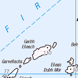
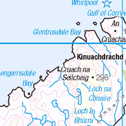
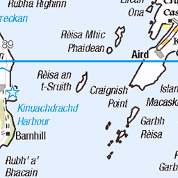
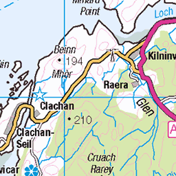
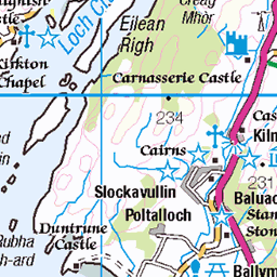
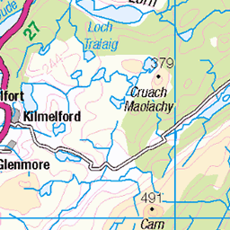
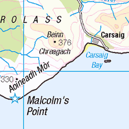
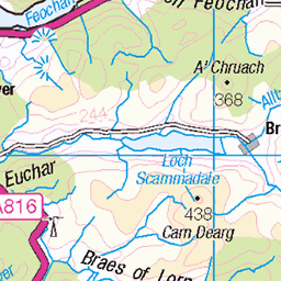
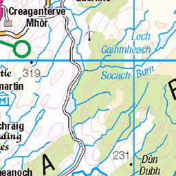
OS Map of Guirasdeal
Height: 33m / 108ft • Prominence: 33m / 108ft • Summit : grassy outcrop • Trip reports (hill-bagging)

Puffin pow-wow
Isle of Lunga puffins
islands scotland highlands nikon scottish puffin isleofmull puffins isles seabirds d600 treshnish turasmara isleoflunga dubhard 19994840251

He's behiiiiiind you!
Another shot from my superb trip to Lunga last weekend.
15-Jun-13 • Pog's pix • flickr
bird scotland funny wildlife beak coastal puffin colourful seabird fright lunga fratercula fraterculaarctica auk treshnishisles alcidae 9103447568

Puffin portrait
Another shot from my trip to Lunga last year. A close-up of a pretty puffin. The beak is a little soft, and I've blown the whites on its chest, but other than that I'm fairly happy with this :D
15-Jun-13 • Pog's pix • flickr
portrait orange white black detail bird eye nature yellow closeup island scotland head wildlife small beak feather coastal puffin colourful seabird lunga fraterculaarctica auk treshnishisles alcidae 15588909247

mesmerised and hypnotised by puffin antics!
Having captured so many images of the puffins, I thought it best to show some collectively rather than bore you all with my puffinitis, which is quite contagious once you meet them!
scotland highlands nikon scottish mara puffins mull seabirds lunga d600 treshnishisles seatrip turusmara dubhard 19828147128

Scarba
16-Apr-11 • Ashley Middleton Photography • flickr
sea cloud mountain water weather landmarks 18200mm geographicfeatures 5687703390

Scarba
15-Apr-11 • Ashley Middleton Photography • flickr
sea water island coast rocks 18200mm geographicfeatures 5687016732
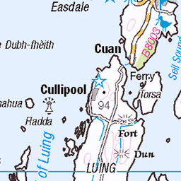
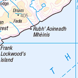
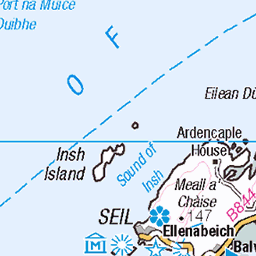
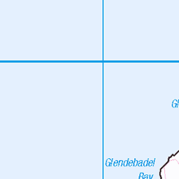
OS Map
This is OS mapping. In some areas, OpenStreetMap shows more footpaths
Spatial NI has online OSNI mapping. Click "Basemap Gallery" (4 squares icon at the top).
Now would be a good time for a cup of tea.


GPX Editor
Record map clicks
Reload map
Photos
Please tag your photos and upload them to the British and Irish Mountains group on Flickr
The other photos have been geo-tagged as on or around the summit. For less busy mountains, it can be a little hit and miss.
Puffin pow-wow
Isle of Lunga puffins
islands scotland highlands nikon scottish puffin isleofmull puffins isles seabirds d600 treshnish turasmara isleoflunga dubhard 19994840251
He's behiiiiiind you!
Another shot from my superb trip to Lunga last weekend.
15-Jun-13 • Pog's pix • flickr
bird scotland funny wildlife beak coastal puffin colourful seabird fright lunga fratercula fraterculaarctica auk treshnishisles alcidae 9103447568
Puffin portrait
Another shot from my trip to Lunga last year. A close-up of a pretty puffin. The beak is a little soft, and I've blown the whites on its chest, but other than that I'm fairly happy with this :D
15-Jun-13 • Pog's pix • flickr
portrait orange white black detail bird eye nature yellow closeup island scotland head wildlife small beak feather coastal puffin colourful seabird lunga fraterculaarctica auk treshnishisles alcidae 15588909247
mesmerised and hypnotised by puffin antics!
Having captured so many images of the puffins, I thought it best to show some collectively rather than bore you all with my puffinitis, which is quite contagious once you meet them!
scotland highlands nikon scottish mara puffins mull seabirds lunga d600 treshnishisles seatrip turusmara dubhard 19828147128
Scarba
16-Apr-11 • Ashley Middleton Photography • flickr
sea cloud mountain water weather landmarks 18200mm geographicfeatures 5687703390
Scarba
15-Apr-11 • Ashley Middleton Photography • flickr
sea water island coast rocks 18200mm geographicfeatures 5687016732

Scarba
15-Apr-11 • Ashley Middleton Photography • flickr
sea cloud mountain water weather island coast rocks 18200mm geographicfeatures 5686449103

Scarba
15-Apr-11 • Ashley Middleton Photography • flickr
sea mountain water island coast rocks 18200mm geographicfeatures 5687018230
Videos
None found
Notes
- Data: Database of British and Irish Hills v18.2
- Maps: We use OS mapping for England, Scotland, Wales, and the Isle of Man. Sadly, Channel Islands, Northern (OSNI) and Southern Ireland (OSI) mapping isn't available online, so we use Openstreetmap.