Hills of Britain and Ireland
OS Map of Meall na Aighean
Height: 981m / 3219ft • Prominence: 136m / 446ft • Summit : rock 2m N of cairn • Trip reports (hill-bagging)

P1105236
Frost on the summit of Meall na Aighean above Glen Lyon
17-Nov-24 • Knee Bother • flickr
54148185844


Late light over Glen Lyon
04-Mar-24 • Clive Dyson • flickr
aberfeldy scotland unitedkingdom 54042116133
Looking back at the day's Munros, Glen Lyon, Scotland
Two weeks hiking in Scotland. Day 3 above Glen Lyon. Starting from near Invervar, we hiked up and over 4 Munros, Carn Gorm, Maell Garb, Carn Mairg and Maell na Aighean. After a cold, cloudy start we had a wonderful sunny day. Spectacular views to Schiehallion and the Cairngorms to the north and east, the Lawers group of hills to the south and to Glen Lyon below.
29-Aug-21 • Miche & Jon Rousell • flickr
scotland perthshire stirling aberfeldy highlands glen lyon invervar munro bagging carngorm maellgarb carnmairg maellnaaighean schiehallion iphone iphonography iphone11 pano panorama 51681061342

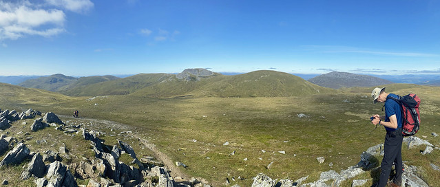
View back at our days hike from Maell na Aighean, Scotland
Two weeks hiking in Scotland. Day 3 above Glen Lyon. Starting from near Invervar, we hiked up and over 4 Munros, Carn Gorm, Maell Garb, Carn Mairg and Maell na Aighean. After a cold, cloudy start we had a wonderful sunny day. Spectacular views to Schiehallion and the Cairngorms to the north and east, the Lawers group of hills to the south and to Glen Lyon below.
29-Aug-21 • Miche & Jon Rousell • flickr
scotland perthshire stirling aberfeldy highlands glen lyon invervar munro bagging carngorm maellgarb carnmairg maellnaaighean schiehallion iphone iphonography iphone11 51632313717

Looking down to Glen Lyon, Scotland
Two weeks hiking in Scotland. Day 3 above Glen Lyon. Starting from near Invervar, we hiked up and over 4 Munros, Carn Gorm, Maell Garb, Carn Mairg and Maell na Aighean. After a cold, cloudy start we had a wonderful sunny day. Spectacular views to Schiehallion and the Cairngorms to the north and east, the Lawers group of hills to the south and to Glen Lyon below.
29-Aug-21 • Miche & Jon Rousell • flickr
scotland perthshire stirling aberfeldy highlands glen lyon invervar munro bagging carngorm maellgarb carnmairg maellnaaighean schiehallion iphone iphonography iphone11 51759370143
OS Map
This is OS mapping. In some areas, OpenStreetMap shows more footpaths
Spatial NI has online OSNI mapping. Click "Basemap Gallery" (4 squares icon at the top).
Now would be a good time for a cup of tea.
GPX Editor
Record map clicks
Reload map
Photos
Please tag your photos and upload them to the British and Irish Mountains group on Flickr
The other photos have been geo-tagged as on or around the summit. For less busy mountains, it can be a little hit and miss.
P1105236
Frost on the summit of Meall na Aighean above Glen Lyon
17-Nov-24 • Knee Bother • flickr
54148185844
Late light over Glen Lyon
04-Mar-24 • Clive Dyson • flickr
aberfeldy scotland unitedkingdom 54042116133
Looking back at the day's Munros, Glen Lyon, Scotland
Two weeks hiking in Scotland. Day 3 above Glen Lyon. Starting from near Invervar, we hiked up and over 4 Munros, Carn Gorm, Maell Garb, Carn Mairg and Maell na Aighean. After a cold, cloudy start we had a wonderful sunny day. Spectacular views to Schiehallion and the Cairngorms to the north and east, the Lawers group of hills to the south and to Glen Lyon below.
29-Aug-21 • Miche & Jon Rousell • flickr
scotland perthshire stirling aberfeldy highlands glen lyon invervar munro bagging carngorm maellgarb carnmairg maellnaaighean schiehallion iphone iphonography iphone11 pano panorama 51681061342
View back at our days hike from Maell na Aighean, Scotland
Two weeks hiking in Scotland. Day 3 above Glen Lyon. Starting from near Invervar, we hiked up and over 4 Munros, Carn Gorm, Maell Garb, Carn Mairg and Maell na Aighean. After a cold, cloudy start we had a wonderful sunny day. Spectacular views to Schiehallion and the Cairngorms to the north and east, the Lawers group of hills to the south and to Glen Lyon below.
29-Aug-21 • Miche & Jon Rousell • flickr
scotland perthshire stirling aberfeldy highlands glen lyon invervar munro bagging carngorm maellgarb carnmairg maellnaaighean schiehallion iphone iphonography iphone11 51632313717
Looking down to Glen Lyon, Scotland
Two weeks hiking in Scotland. Day 3 above Glen Lyon. Starting from near Invervar, we hiked up and over 4 Munros, Carn Gorm, Maell Garb, Carn Mairg and Maell na Aighean. After a cold, cloudy start we had a wonderful sunny day. Spectacular views to Schiehallion and the Cairngorms to the north and east, the Lawers group of hills to the south and to Glen Lyon below.
29-Aug-21 • Miche & Jon Rousell • flickr
scotland perthshire stirling aberfeldy highlands glen lyon invervar munro bagging carngorm maellgarb carnmairg maellnaaighean schiehallion iphone iphonography iphone11 51759370143

Hills above Invervar
On the way back down to Invervar after the circuit of the four Càrn Mairg munros. The start of the route heads up the peak in the distance (Carn Gorm) above the forestry plantation. This cairn was tucked away on the hillside below Meall nan Aighean, overlooking Gleann Pollaidh. No idea what it signifies or commemorates. It wasn't visible from the main path and had no inscription or plaque, but it seemed old and well-built, definitely not your standard 'route-marker' type cairn.
23-Sep-18 • OutdoorMonkey • flickr
càrnmairggroup meallnanaighean invervar cairn stones hills hillside mountain mountainside munro carngorm countryside rural nature outside outdoor scenic scenery landscape 45237405962


Glen Lyon, Perthshire and Kinross
scotland schottland glenlyon grosbritannien 26900965173

Videos
My third outing with the drone at Glen Lyon, Invervar, Scotland.
The full description of the walk can be found here, at the walk highlands web site.
Lovely start to the day soon changed to Claggy and Blowin a Hooly. Featuring Ptarmagin. #CarnGorm #MeallGarbh #CarnMairg ...
Join Alistair as he visits an unusual summit cairn above Glen Lyon, which almost looks like the Iron Throne from Game of Thrones, ...
Notes
- Data: Database of British and Irish Hills v18.2
- Maps: We use OS mapping for England, Scotland, Wales, and the Isle of Man. Sadly, Channel Islands, Northern (OSNI) and Southern Ireland (OSI) mapping isn't available online, so we use Openstreetmap.