Hills of Britain and Ireland
OS Map of Ben Wyvis - Glas Leathad Mor
Height: 1046m / 3432ft • Prominence: 691m / 2267ft • Summit : trig point • Trip reports (hill-bagging)


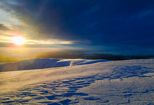
Sunrise from the summit of Ben Wyvis
28-Dec-20 • Masa Sakano • flickr
activity benwyvis highland place scotland climbing scenery sunrise winterclimbing 50807928358
Sunrise 2
28-Dec-20 • Masa Sakano • flickr
activity benwyvis highland place scotland climbing scenery sunrise winterclimbing 50808672256

Panoramic view of sunrise from the Ben Wyvis summit
28-Dec-20 • Masa Sakano • flickr
activity benwyvis highland place scotland climbing scenery sunrise winterclimbing 50808786197

OS Map
This is OS mapping. In some areas, OpenStreetMap shows more footpaths
Spatial NI has online OSNI mapping. Click "Basemap Gallery" (4 squares icon at the top).
Now would be a good time for a cup of tea.
GPX Editor
Record map clicks
Reload map
Photos
Please tag your photos and upload them to the British and Irish Mountains group on Flickr
The other photos have been geo-tagged as on or around the summit. For less busy mountains, it can be a little hit and miss.
Sunrise from the summit of Ben Wyvis
28-Dec-20 • Masa Sakano • flickr
activity benwyvis highland place scotland climbing scenery sunrise winterclimbing 50807928358
Sunrise 2
28-Dec-20 • Masa Sakano • flickr
activity benwyvis highland place scotland climbing scenery sunrise winterclimbing 50808672256
Panoramic view of sunrise from the Ben Wyvis summit
28-Dec-20 • Masa Sakano • flickr
activity benwyvis highland place scotland climbing scenery sunrise winterclimbing 50808786197


Videos
Join Alistair and Douglas on the first day of their week long adventure to the North West of Scotland. To get things started, they ...
Panoramic shot from the top of Ben Wyvis (Glas Leathad Mor)
munro #munrowalking #benwyvis #easterross #scotland #scottishhighlands.
23.07.2024 Ben Wyvis. A nice beginners Munro.
Myself & Robin headed up the NW Highlands for a Wild Camping weekend. Friday night saw us ascending Ben Wyvis at 10pm, ...
Notes
- Data: Database of British and Irish Hills v18.2
- Maps: We use OS mapping for England, Scotland, Wales, and the Isle of Man. Sadly, Channel Islands, Northern (OSNI) and Southern Ireland (OSI) mapping isn't available online, so we use Openstreetmap.