Hills of Britain and Ireland
OS Map of Meall nam Peithirean

photo
Looking south-east from the highest point (Sgurr Mor) in the Fannich mountains near Ullapool in Scotland.
19-May-23 • OutdoorMonkey • flickr
sgurrmor fannich fannichs mountain mountains ridge scotland highlands cairn summit peak munro wild wilderness remote countryside outside outdoor rural scenic scenery 52963787799
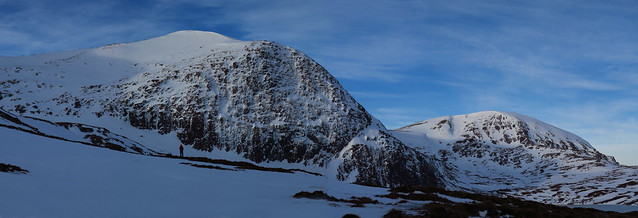
Creag a' Mhadaidh, Fannichs
The icy cliffs of Creag a' Mhadaidh below Càrn na Criche (961 m) Fannichs, Wester Ross
22-Jan-19 • Colin Wells • flickr
fannichhillssssi càrnnacriche fannichs fannaichs creagàmhadaidh 31900680037


Grand Isolation
Grand Isolation crag, Eag nam Fear-bogha, Fannichs, Ross-shire
23-Feb-18 • Colin Wells • flickr
iceclimbing winterclimbing grandisolation eagnamfearbogha fannichhillssssi fannichs fannaichs scottishhighlands westerross stephenreid 39873514025

Lone Star
Stephen Reid on the first ascent of Lone Star (VI, 6) on Icicle Works Buttress, Eag nam Fear-bogha, Fannichs, Wester Ross, Scotland
23-Feb-18 • Colin Wells • flickr
iceclimbing icicleworksbuttress fannichs fannaichs westerross scottishhighlands eagnamfearbogha 32938339288

Grand Isolation and Icicle Works Crags
Stephen Reid approaching Grand Isolation (V, 5) on Grand Isolation Crag, Eag nam Fear-bogha, Fannichs, Scotland. Icicle Works crag is the crag beyond. Although quite small by Scottish standards, the technical ice routes here are uniformly steep and pack quite a punch.
01-Feb-18 • Colin Wells • flickr
eagnamfearbogha stephenreid fannichs fannichhillssssi siteofspecialscientificinterest fannaichs iceclimbing winterclimbing westerross grandisolationcrag grandisolation icicleworkscrag scottishhighlands 47628196101
OS Map
This is OS mapping. In some areas, OpenStreetMap shows more footpaths
Spatial NI has online OSNI mapping. Click "Basemap Gallery" (4 squares icon at the top).
Now would be a good time for a cup of tea.
GPX Editor
Record map clicks
Reload map
Photos
Please tag your photos and upload them to the British and Irish Mountains group on Flickr
The other photos have been geo-tagged as on or around the summit. For less busy mountains, it can be a little hit and miss.
photo
Looking south-east from the highest point (Sgurr Mor) in the Fannich mountains near Ullapool in Scotland.
19-May-23 • OutdoorMonkey • flickr
sgurrmor fannich fannichs mountain mountains ridge scotland highlands cairn summit peak munro wild wilderness remote countryside outside outdoor rural scenic scenery 52963787799
Creag a' Mhadaidh, Fannichs
The icy cliffs of Creag a' Mhadaidh below Càrn na Criche (961 m) Fannichs, Wester Ross
22-Jan-19 • Colin Wells • flickr
fannichhillssssi càrnnacriche fannichs fannaichs creagàmhadaidh 31900680037
Grand Isolation
Grand Isolation crag, Eag nam Fear-bogha, Fannichs, Ross-shire
23-Feb-18 • Colin Wells • flickr
iceclimbing winterclimbing grandisolation eagnamfearbogha fannichhillssssi fannichs fannaichs scottishhighlands westerross stephenreid 39873514025
Lone Star
Stephen Reid on the first ascent of Lone Star (VI, 6) on Icicle Works Buttress, Eag nam Fear-bogha, Fannichs, Wester Ross, Scotland
23-Feb-18 • Colin Wells • flickr
iceclimbing icicleworksbuttress fannichs fannaichs westerross scottishhighlands eagnamfearbogha 32938339288
Grand Isolation and Icicle Works Crags
Stephen Reid approaching Grand Isolation (V, 5) on Grand Isolation Crag, Eag nam Fear-bogha, Fannichs, Scotland. Icicle Works crag is the crag beyond. Although quite small by Scottish standards, the technical ice routes here are uniformly steep and pack quite a punch.
01-Feb-18 • Colin Wells • flickr
eagnamfearbogha stephenreid fannichs fannichhillssssi siteofspecialscientificinterest fannaichs iceclimbing winterclimbing westerross grandisolationcrag grandisolation icicleworkscrag scottishhighlands 47628196101


Grand Isolation
First ascent of 'Grand Isolation' (V, 5), Isolation Crag, Fannichs, Ross-shire, Scotland. (Photo by P. Clay)
24-Jan-10 • Colin Wells • flickr
scotland iceclimbing scottishhighlands fannaichs fannichs 4431792960
Videos
None found
Notes
- Data: Database of British and Irish Hills v18.2
- Maps: We use OS mapping for England, Scotland, Wales, and the Isle of Man. Sadly, Channel Islands, Northern (OSNI) and Southern Ireland (OSI) mapping isn't available online, so we use Openstreetmap.