Hills of Britain and Ireland
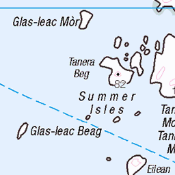
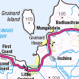
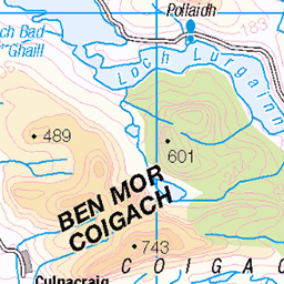
OS Map of Bottle Island
Height: 36m / 118ft • Prominence: 36m / 118ft • Summit : no feature: grass • Trip reports (hill-bagging)

Summer Isles
14-Aug-21 • Stuart.67 • flickr
scotland unitedkingdom nikon z7ii sea summer isles clouds 51378399403

Towards the mainland
18-Jun-21 • goforchris • flickr
isleoflewis outerhebrides scotland holidays ferries caledonianmacbrayne mvlochseaforth 51267988161

Distant mountains
...which I don't know well enough to name
18-Jun-21 • goforchris • flickr
isleoflewis outerhebrides scotland holidays ferries caledonianmacbrayne mvlochseaforth 51268171413

Into Loch Broom
18-Jun-21 • goforchris • flickr
isleoflewis outerhebrides scotland holidays ferries caledonianmacbrayne mvlochseaforth 51267215222

Approaching Ullapool
08-Sep-18 • Donald Morrison • flickr
ullapool caledonianmcbrayne ferry calmac lochseaforth sea harbour coast 43899949634

A832 between Sand and First Coast, Scotland.
« If you appreciate my work and would like to support me becoming an independent photographer, become a Patreon supporter at www.patreon.com/alexdehaas" rel="noreferrer nofollow www.patreon.com/alexdehaas , or buy me a coffee at www.buymeacoffee.com/alexdehaas" rel="noreferrer nofollow www.buymeacoffee.com/alexdehaas :) »
18-Aug-18 • Alex-de-Haas • flickr
aurorahdr aurorahdr2019 bergen blackstone d850 gb greatbritain hdr irix irix11mm irixblackstone laide lightroom nikon nikond850 schotland scotland secondcoast skylum uk unitedkingdom berg cloud clouds coast highlands holidays hooglanden journey kust landscape landschaft landschap lucht mountain mountains nature natuur outdoor outdoors reis reizen roadtrip rondreis sea skies sky summer travel travelling vacation vakantie westcoast wolk wolken zee zomer 51256640586
OS Map
This is OS mapping. In some areas, OpenStreetMap shows more footpaths
Spatial NI has online OSNI mapping. Click "Basemap Gallery" (4 squares icon at the top).
Now would be a good time for a cup of tea.


GPX Editor
Record map clicks
Reload map
Photos
Please tag your photos and upload them to the British and Irish Mountains group on Flickr
The other photos have been geo-tagged as on or around the summit. For less busy mountains, it can be a little hit and miss.
Summer Isles
14-Aug-21 • Stuart.67 • flickr
scotland unitedkingdom nikon z7ii sea summer isles clouds 51378399403
Towards the mainland
18-Jun-21 • goforchris • flickr
isleoflewis outerhebrides scotland holidays ferries caledonianmacbrayne mvlochseaforth 51267988161
Distant mountains
...which I don't know well enough to name
18-Jun-21 • goforchris • flickr
isleoflewis outerhebrides scotland holidays ferries caledonianmacbrayne mvlochseaforth 51268171413
Into Loch Broom
18-Jun-21 • goforchris • flickr
isleoflewis outerhebrides scotland holidays ferries caledonianmacbrayne mvlochseaforth 51267215222
Approaching Ullapool
08-Sep-18 • Donald Morrison • flickr
ullapool caledonianmcbrayne ferry calmac lochseaforth sea harbour coast 43899949634
A832 between Sand and First Coast, Scotland.
« If you appreciate my work and would like to support me becoming an independent photographer, become a Patreon supporter at www.patreon.com/alexdehaas" rel="noreferrer nofollow www.patreon.com/alexdehaas , or buy me a coffee at www.buymeacoffee.com/alexdehaas" rel="noreferrer nofollow www.buymeacoffee.com/alexdehaas :) »
18-Aug-18 • Alex-de-Haas • flickr
aurorahdr aurorahdr2019 bergen blackstone d850 gb greatbritain hdr irix irix11mm irixblackstone laide lightroom nikon nikond850 schotland scotland secondcoast skylum uk unitedkingdom berg cloud clouds coast highlands holidays hooglanden journey kust landscape landschaft landschap lucht mountain mountains nature natuur outdoor outdoors reis reizen roadtrip rondreis sea skies sky summer travel travelling vacation vakantie westcoast wolk wolken zee zomer 51256640586

10117 Bottle Island a
Landed SE shore near the east corner and then an easy slabby scramble to gain the summit which has beautiful views. Name: Bottle Island Hill number: 10117 Height:36m / 118ft Parent (Ma/M):none Section: 16F: Lochinver to Ullapool County/UA: Highland (UA) Island:Mono Tump island Maritime Area:Gruinard & The Summer Isles Class:Tump (0-99m), SIB Grid ref: NB953019 (est) Drop: 36m Col: Sea
25-Jul-15 • Dugswell2 • flickr
summerisles tump p36 bottleisland islandtop 20666103882

10117 Bottle Island
Landed SE shore near the east corner and then an easy slabby scramble to gain the summit which has beautiful views. Name: Bottle Island Hill number: 10117 Height:36m / 118ft Parent (Ma/M):none Section: 16F: Lochinver to Ullapool County/UA: Highland (UA) Island:Mono Tump island Maritime Area:Gruinard & The Summer Isles Class:Tump (0-99m), SIB Grid ref: NB953019 (est) Drop: 36m Col: Sea
25-Jul-15 • Dugswell2 • flickr
summerisles tump p36 bottleisland islandtop 20666096332

Videos
None found
Notes
- Data: Database of British and Irish Hills v18.2
- Maps: We use OS mapping for England, Scotland, Wales, and the Isle of Man. Sadly, Channel Islands, Northern (OSNI) and Southern Ireland (OSI) mapping isn't available online, so we use Openstreetmap.